Le Pêchereau geodata
Le Pêchereau (Centre) is a populated place; located in France in Europe/Paris (GMT+2) time zone. With population of 1,906 people, there are 5019 cities with bigger population in this country. Compared to other cities in France, 59.4% of cities are located further ↑North; 62.4% of cities are located further →East and 53.1% of cities have higher elevation than Le Pêchereau. Note1
Administrative division(s):
- Level 1: Centre
- Level 2: Département de l'Indre
- Level 3: Arrondissement de Châteauroux
- Level 4: Le Pêchereau


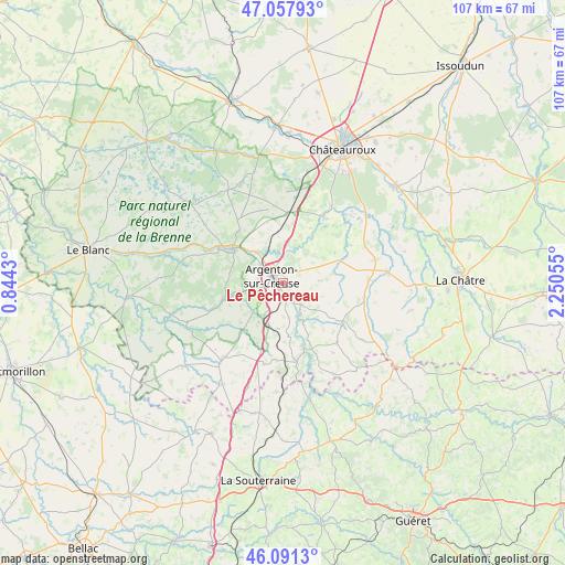
Le Pêchereau GPS coordinates[2]
46° 34' 36.372" North, 1° 32' 50.748" East
| Map corner | latitude | longitude |
|---|---|---|
| Upper-left | 47.05793°, | 0.8443° |
| Center: | 46.57677°, | 1.54743° |
| Lower-right: | 46.0913°, | 2.25055° |
| Map W x H: | 107.5×107.5 km | = 66.8×66.8mi |
| max Lat: | 51.07786° ⇑59.4% North |
| Le Pêchereau: | 46.57677° |
| min Lat: | ⇓40.6% South 41.3874° |
| min Long | Le Pêchereau | max Long |
| -5.08615° | 1.54743° | 9.52242° |
| W 37.6%⇐ | ⇒62.4% E |
Elevation
Elevation of Le Pêchereau is 122 m = 400 ft, and this is 71.7 m = 235 ft below average elevation for this country.
| Max E: |
2333 m = 7654 ft | 53.1% |
| Avg. | 193.7 m = 635 ft | |
| Le Pêchereau | 122 m = 400 ft | |
Min E: |
-1 m = -3 ft | 46.9% |
See also: France elevation on elevation.city.
Geographical zone
Le Pêchereau is located in North temperate zone (between Tropic of Cancer and the Arctic Circle). Distance of this North polar circle is 2222.3 km =1380.9 mi to North.| Distance of | km | miles | from Le Pêchereau |
|---|---|---|---|
| North Pole | 4828.2 | 3000.1 | to North |
| Arctic Circle | 2222.3 | 1380.9 | to North |
| Tropic Cancer | 2572.9 | 1598.7 | to South |
| Equator | 5178.9 | 3218 | to South |


Nearby cities:
15 places around Le Pêchereau: (largest is in red/bold)
• Argenton-sur-Creuse
2.6 km =1.6 mi,  304°
304°
• Badecon-le-Pin
5.4 km =3.4 mi,  137°
137°
• Ceaulmont
6.3 km =3.9 mi,  160°
160°
• Chabenet
6.5 km =4 mi,  324°
324°
• Chasseneuil
8.7 km =5.4 mi,  333°
333°
• Cluis
15.8 km =9.8 mi,  102°
102°
• Cuzion
11.8 km =7.3 mi, 157°
• Orsennes
15.2 km =9.4 mi, 137°
• Parnac
15.9 km =9.9 mi,  210°
210°
• Rivarennes
13.9 km =8.6 mi, 298°
• Saint-Gaultier
12.2 km =7.6 mi, 302°
• Saint-Marcel
3.8 km =2.4 mi, 316°
• Thenay
10.9 km =6.8 mi, 303°
• Velles
14.7 km =9.1 mi,  31°
31°
• Éguzon-Chantôme
14.4 km =8.9 mi,  168°
168°
Sources, notices
• [Note1] Compared only with cities in France existing in our database
• [Src1] Map data: © OpenStreetMap contributors (CC-BY-SA)
• [Src2] Other city data from geonames.org with taken over terms of usage.
• [Src3] Geographical zone / Annual Mean Temperature by Robert A. Rohde @ Wikipedia
