Chabenet geodata
Chabenet (Centre) is a populated place; located in France in Europe/Paris (GMT+2) time zone. With population of 892 people, there are 9724 cities with bigger population in this country. Compared to other cities in France, 59% of cities are located further ↑North; 63% of cities are located further →East and 52.2% of cities have lower elevation than Chabenet. Note1
Administrative division(s):
- Level 1: Centre
- Level 2: Département de l'Indre
- Level 3: Arrondissement de Châteauroux
- Level 4: Le Pont-Chrétien-Chabenet


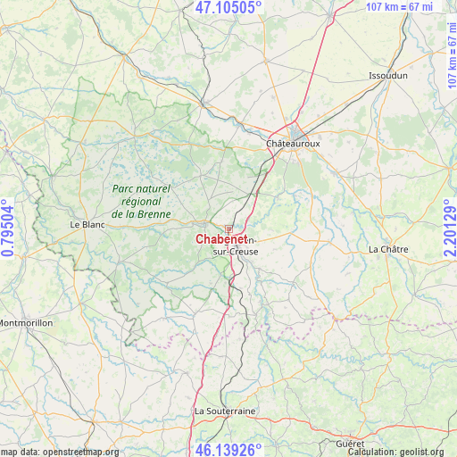
Chabenet GPS coordinates[2]
46° 37' 27.516" North, 1° 29' 53.412" East
| Map corner | latitude | longitude |
|---|---|---|
| Upper-left | 47.10505°, | 0.79504° |
| Center: | 46.62431°, | 1.49817° |
| Lower-right: | 46.13926°, | 2.20129° |
| Map W x H: | 107.4×107.4 km | = 66.7×66.7mi |
| max Lat: | 51.07786° ⇑59% North |
| Chabenet: | 46.62431° |
| min Lat: | ⇓41% South 41.3874° |
| min Long | Chabenet | max Long |
| -5.08615° | 1.49817° | 9.52242° |
| W 37%⇐ | ⇒63% E |
Elevation
Elevation of Chabenet is 140 m = 459 ft, and this is 53.7 m = 176 ft below average elevation for this country.
| Max E: |
2333 m = 7654 ft | 47.8% |
| Avg. | 193.7 m = 635 ft | |
| Chabenet | 140 m = 459 ft | |
Min E: |
-1 m = -3 ft | 52.2% |
See also: France elevation on elevation.city.
Geographical zone
Chabenet is located in North temperate zone (between Tropic of Cancer and the Arctic Circle). Distance of this North polar circle is 2217 km =1377.6 mi to North.| Distance of | km | miles | from Chabenet |
|---|---|---|---|
| North Pole | 4822.9 | 2996.8 | to North |
| Arctic Circle | 2217 | 1377.6 | to North |
| Tropic Cancer | 2578.2 | 1602 | to South |
| Equator | 5184.1 | 3221.2 | to South |


Nearby cities:
15 places around Chabenet: (largest is in red/bold)
• Argenton-sur-Creuse
4.2 km =2.6 mi,  156°
156°
• Arthon
17.1 km =10.6 mi,  63°
63°
• Badecon-le-Pin
11.8 km =7.3 mi,  141°
141°
• Ceaulmont
12.7 km =7.9 mi,  152°
152°
• Chasseneuil
2.5 km =1.6 mi,  357°
357°
• Cuzion
18.1 km =11.2 mi, 152°
• Le Pêchereau
6.5 km =4 mi, 144°
• Luant
12.9 km =8 mi,  20°
20°
• Neuillay-les-Bois
15.8 km =9.8 mi,  353°
353°
• Prissac
19.2 km =11.9 mi,  228°
228°
• Rivarennes
8.6 km =5.3 mi,  278°
278°
• Saint-Gaultier
6.6 km =4.1 mi, 280°
• Saint-Marcel
2.7 km =1.7 mi, 155°
• Thenay
5.4 km =3.4 mi, 277°
• Velles
13.6 km =8.5 mi, 58°
Sources, notices
• [Note1] Compared only with cities in France existing in our database
• [Src1] Map data: © OpenStreetMap contributors (CC-BY-SA)
• [Src2] Other city data from geonames.org with taken over terms of usage.
• [Src3] Geographical zone / Annual Mean Temperature by Robert A. Rohde @ Wikipedia
