Le Kremlin-Bicêtre geodata
Le Kremlin-Bicêtre (Île-de-France) is a populated place; located in France in Europe/Paris (GMT+2) time zone. With population of 27,867 people, there are 306 cities with bigger population in this country. Compared to other cities in France, 75.8% of cities are located further ↓South; 51.6% of cities are located further →East and 75.4% of cities have higher elevation than Le Kremlin-Bicêtre. Note1
Administrative division(s):
- Level 1: Île-de-France
- Level 2: Val-de-Marne
- Level 3: Arrondissement de L'Haÿ-les-Roses
- Level 4: Le Kremlin-Bicêtre


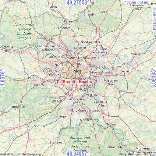
Le Kremlin-Bicêtre GPS coordinates[2]
48° 48' 52.956" North, 2° 21' 38.628" East
| Map corner | latitude | longitude |
|---|---|---|
| Upper-left | 49.27558°, | 1.6576° |
| Center: | 48.81471°, | 2.36073° |
| Lower-right: | 48.34957°, | 3.06385° |
| Map W x H: | 103×103 km | = 64×64mi |
| max Lat: | 51.07786° ⇑24.2% North |
| Le Kremlin-Bicêtre: | 48.81471° |
| min Lat: | ⇓75.8% South 41.3874° |
| min Long | Le Kremlin-Bic� | max Long |
| -5.08615° | 2.36073° | 9.52242° |
| W 48.4%⇐ | ⇒51.6% E |
Elevation
Elevation of Le Kremlin-Bicêtre is 66 m = 217 ft, and this is 127.7 m = 419 ft below average elevation for this country.
| Max E: |
2333 m = 7654 ft | 75.4% |
| Avg. | 193.7 m = 635 ft | |
| Le Kremlin-Bicêtre | 66 m = 217 ft | |
Min E: |
-1 m = -3 ft | 24.6% |
See also: France elevation on elevation.city.
Geographical zone
Le Kremlin-Bicêtre is located in North temperate zone (between Tropic of Cancer and the Arctic Circle). Distance of this North polar circle is 1973.5 km =1226.3 mi to North.| Distance of | km | miles | from Le Kremlin-Bicêtre |
|---|---|---|---|
| North Pole | 4579.4 | 2845.5 | to North |
| Arctic Circle | 1973.5 | 1226.3 | to North |
| Tropic Cancer | 2821.8 | 1753.4 | to South |
| Equator | 5427.7 | 3372.6 | to South |


Nearby cities:
15 places around Le Kremlin-Bicêtre: (largest is in red/bold)
• Alfortville
4.5 km =2.8 mi,  102°
102°
• Arcueil
2.6 km =1.6 mi,  231°
231°
• Bagneux
4.4 km =2.7 mi,  241°
241°
• Cachan
2.7 km =1.7 mi,  220°
220°
• Charenton-le-Pont
3.9 km =2.4 mi,  77°
77°
• Gentilly
1.4 km =0.9 mi,  261°
261°
• Ivry-sur-Seine
1.8 km =1.1 mi,  86°
86°
• L'Haÿ-les-Roses
4 km =2.5 mi,  209°
209°
• Malakoff
4.5 km =2.8 mi,  277°
277°
• Montrouge
3.4 km =2.1 mi,  272°
272°
• Paris
4.4 km =2.7 mi,  348°
348°
• Saint-Mandé
4.8 km =3 mi,  56°
56°
• Saint-Maurice
4.9 km =3 mi, 80°
• Villejuif
2.3 km =1.4 mi,  181°
181°
• Vitry-sur-Seine
4.4 km =2.7 mi,  134°
134°
Sources, notices
• [Note1] Compared only with cities in France existing in our database
• [Src1] Map data: © OpenStreetMap contributors (CC-BY-SA)
• [Src2] Other city data from geonames.org with taken over terms of usage.
• [Src3] Geographical zone / Annual Mean Temperature by Robert A. Rohde @ Wikipedia
