Charenton-le-Pont geodata
Charenton-le-Pont (Île-de-France) is a populated place; located in France in Europe/Paris (GMT+2) time zone. With population of 30,910 people, there are 260 cities with bigger population in this country. Compared to other cities in France, 76% of cities are located further ↓South; 50.9% of cities are located further →East and 80.6% of cities have higher elevation than Charenton-le-Pont. Note1
Administrative division(s):
- Level 1: Île-de-France
- Level 2: Val-de-Marne
- Level 3: Arrondissement de Nogent-sur-Marne
- Level 4: Charenton-le-Pont


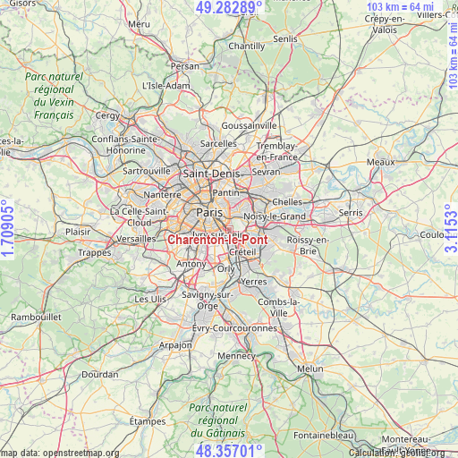
Charenton-le-Pont GPS coordinates[2]
48° 49' 19.524" North, 2° 24' 43.812" East
| Map corner | latitude | longitude |
|---|---|---|
| Upper-left | 49.28289°, | 1.70905° |
| Center: | 48.82209°, | 2.41217° |
| Lower-right: | 48.35701°, | 3.1153° |
| Map W x H: | 102.9×102.9 km | = 63.9×63.9mi |
| max Lat: | 51.07786° ⇑24% North |
| Charenton-le-Pont: | 48.82209° |
| min Lat: | ⇓76% South 41.3874° |
| min Long | Charenton-le-Po | max Long |
| -5.08615° | 2.41217° | 9.52242° |
| W 49.1%⇐ | ⇒50.9% E |
Elevation
Elevation of Charenton-le-Pont is 53 m = 174 ft, and this is 140.7 m = 462 ft below average elevation for this country.
| Max E: |
2333 m = 7654 ft | 80.6% |
| Avg. | 193.7 m = 635 ft | |
| Charenton-le-Pont | 53 m = 174 ft | |
Min E: |
-1 m = -3 ft | 19.4% |
See also: France elevation on elevation.city.
Geographical zone
Charenton-le-Pont is located in North temperate zone (between Tropic of Cancer and the Arctic Circle). Distance of this North polar circle is 1972.7 km =1225.8 mi to North.| Distance of | km | miles | from Charenton-le-Pont |
|---|---|---|---|
| North Pole | 4578.6 | 2845 | to North |
| Arctic Circle | 1972.7 | 1225.8 | to North |
| Tropic Cancer | 2822.6 | 1753.9 | to South |
| Equator | 5428.5 | 3373.1 | to South |


Nearby cities:
15 places around Charenton-le-Pont: (largest is in red/bold)
• Alfortville
1.9 km =1.2 mi,  161°
161°
• Bagnolet
5 km =3.1 mi,  3°
3°
• Créteil
5.1 km =3.2 mi,  129°
129°
• Gentilly
5.3 km =3.3 mi,  258°
258°
• Ivry-sur-Seine
2.1 km =1.3 mi,  250°
250°
• Joinville-le-Pont
4.6 km =2.9 mi,  85°
85°
• Le Kremlin-Bicêtre
3.9 km =2.4 mi, 257°
• Maisons-Alfort
2.3 km =1.4 mi,  120°
120°
• Montreuil
5.2 km =3.2 mi,  25°
25°
• Nogent-sur-Marne
5.4 km =3.4 mi,  72°
72°
• Saint-Mandé
1.9 km =1.2 mi,  8°
8°
• Saint-Maurice
1.1 km =0.7 mi, 91°
• Villejuif
4.9 km =3 mi,  230°
230°
• Vincennes
3.5 km =2.2 mi, 32°
• Vitry-sur-Seine
3.9 km =2.4 mi,  189°
189°
Sources, notices
• [Note1] Compared only with cities in France existing in our database
• [Src1] Map data: © OpenStreetMap contributors (CC-BY-SA)
• [Src2] Other city data from geonames.org with taken over terms of usage.
• [Src3] Geographical zone / Annual Mean Temperature by Robert A. Rohde @ Wikipedia
