Ivry-sur-Seine geodata
Ivry-sur-Seine (Île-de-France) is a populated place; located in France in Europe/Paris (GMT+2) time zone. With population of 57,897 people, there are 90 cities with bigger population in this country. Compared to other cities in France, 75.9% of cities are located further ↓South; 51.3% of cities are located further →East and 87.4% of cities have higher elevation than Ivry-sur-Seine. Note1
Administrative division(s):
- Level 1: Île-de-France
- Level 2: Val-de-Marne
- Level 3: Arrondissement de L'Haÿ-les-Roses
- Level 4: Ivry-sur-Seine


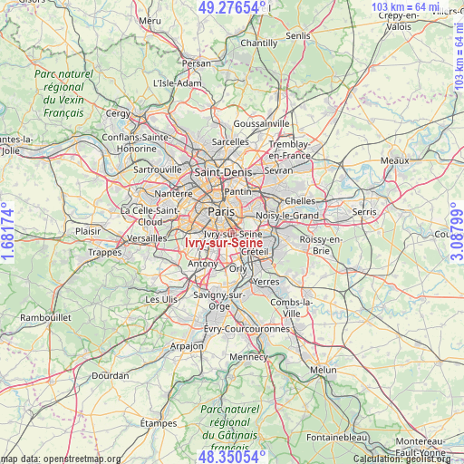
Ivry-sur-Seine GPS coordinates[2]
48° 48' 56.448" North, 2° 23' 5.532" East
| Map corner | latitude | longitude |
|---|---|---|
| Upper-left | 49.27654°, | 1.68174° |
| Center: | 48.81568°, | 2.38487° |
| Lower-right: | 48.35054°, | 3.08799° |
| Map W x H: | 103×103 km | = 64×64mi |
| max Lat: | 51.07786° ⇑24.1% North |
| Ivry-sur-Seine: | 48.81568° |
| min Lat: | ⇓75.9% South 41.3874° |
| min Long | Ivry-sur-Seine | max Long |
| -5.08615° | 2.38487° | 9.52242° |
| W 48.7%⇐ | ⇒51.3% E |
Elevation
Elevation of Ivry-sur-Seine is 36 m = 118 ft, and this is 157.7 m = 517 ft below average elevation for this country.
| Max E: |
2333 m = 7654 ft | 87.4% |
| Avg. | 193.7 m = 635 ft | |
| Ivry-sur-Seine | 36 m = 118 ft | |
Min E: |
-1 m = -3 ft | 12.6% |
See also: Ivry-sur-Seine elevation on elevation.city.
Geographical zone
Ivry-sur-Seine is located in North temperate zone (between Tropic of Cancer and the Arctic Circle). Distance of this North polar circle is 1973.4 km =1226.2 mi to North.| Distance of | km | miles | from Ivry-sur-Seine |
|---|---|---|---|
| North Pole | 4579.3 | 2845.4 | to North |
| Arctic Circle | 1973.4 | 1226.2 | to North |
| Tropic Cancer | 2821.9 | 1753.4 | to South |
| Equator | 5427.8 | 3372.7 | to South |


Nearby cities:
15 places around Ivry-sur-Seine: (largest is in red/bold)
• Alfortville
2.8 km =1.7 mi,  112°
112°
• Arcueil
4.2 km =2.6 mi,  245°
245°
• Cachan
4.1 km =2.5 mi,  238°
238°
• Charenton-le-Pont
2.1 km =1.3 mi,  70°
70°
• Gentilly
3.2 km =2 mi,  264°
264°
• L'Haÿ-les-Roses
5.2 km =3.2 mi,  226°
226°
• Le Kremlin-Bicêtre
1.8 km =1.1 mi,  266°
266°
• Maisons-Alfort
4 km =2.5 mi,  96°
96°
• Montrouge
5.2 km =3.2 mi, 270°
• Paris
5 km =3.1 mi,  327°
327°
• Saint-Mandé
3.4 km =2.1 mi,  41°
41°
• Saint-Maurice
3.2 km =2 mi,  77°
77°
• Villejuif
3 km =1.9 mi,  217°
217°
• Vincennes
5.3 km =3.3 mi,  46°
46°
• Vitry-sur-Seine
3.4 km =2.1 mi,  156°
156°
Sources, notices
• [Note1] Compared only with cities in France existing in our database
• [Src1] Map data: © OpenStreetMap contributors (CC-BY-SA)
• [Src2] Other city data from geonames.org with taken over terms of usage.
• [Src3] Geographical zone / Annual Mean Temperature by Robert A. Rohde @ Wikipedia
