Bizonnes geodata
Bizonnes (Auvergne-Rhône-Alpes) is a populated place; located in France in Europe/Paris (GMT+2) time zone. With population of 677 people, there are 12108 cities with bigger population in this country. Compared to other cities in France, 74.6% of cities are located further ↑North; 81.5% of cities are located further ←West and 95.1% of cities have lower elevation than Bizonnes. Note1
Administrative division(s):
- Level 1: Auvergne-Rhône-Alpes
- Level 2: Département de l'Isère
- Level 3: Arrondissement de La Tour-du-Pin
- Level 4: Bizonnes


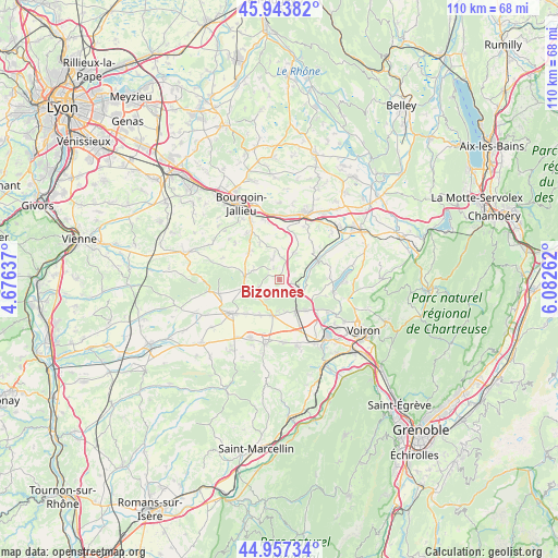
Bizonnes GPS coordinates[2]
45° 27' 9.864" North, 5° 22' 46.164" East
| Map corner | latitude | longitude |
|---|---|---|
| Upper-left | 45.94382°, | 4.67637° |
| Center: | 45.45274°, | 5.37949° |
| Lower-right: | 44.95734°, | 6.08262° |
| Map W x H: | 109.7×109.7 km | = 68.2×68.2mi |
| max Lat: | 51.07786° ⇑74.6% North |
| Bizonnes: | 45.45274° |
| min Lat: | ⇓25.4% South 41.3874° |
| min Long | Bizonnes | max Long |
| -5.08615° | 5.37949° | 9.52242° |
| W 81.5%⇐ | ⇒18.5% E |
Elevation
Elevation of Bizonnes is 593 m = 1946 ft, and this is 399.3 m = 1310 ft above average elevation for this country.
| Max E: |
2333 m = 7654 ft | 4.9% |
| Bizonnes | 593 m 1946 ft | |
| Avg. | 193.7 m = 635 ft | |
Min E: |
-1 m = -3 ft | 95.1% |
See also: France elevation on elevation.city.
Geographical zone
Bizonnes is located in North temperate zone (between Tropic of Cancer and the Arctic Circle). Distance of this North polar circle is 2347.3 km =1458.5 mi to North.| Distance of | km | miles | from Bizonnes |
|---|---|---|---|
| North Pole | 4953.2 | 3077.8 | to North |
| Arctic Circle | 2347.3 | 1458.5 | to North |
| Tropic Cancer | 2448 | 1521.1 | to South |
| Equator | 5053.9 | 3140.3 | to South |


Nearby cities:
15 places around Bizonnes: (largest is in red/bold)
• Badinières
8.6 km =5.3 mi,  315°
315°
• Biol
4.3 km =2.7 mi,  6°
6°
• Bévenais
6.3 km =3.9 mi,  169°
169°
• Champier
6.8 km =4.2 mi,  272°
272°
• Châbons
3.7 km =2.3 mi,  107°
107°
• Châteauvilain
7.9 km =4.9 mi,  330°
330°
• Colombe
8.3 km =5.2 mi,  134°
134°
• Doissin
6.3 km =3.9 mi,  27°
27°
• Eclose
8.1 km =5 mi,  309°
309°
• La Frette
7.3 km =4.5 mi,  192°
192°
• Le Grand-Lemps
7 km =4.3 mi,  153°
153°
• Mottier
6.5 km =4 mi,  239°
239°
• Oyeu
8.2 km =5.1 mi, 114°
• Saint-Hilaire-de-la-Côte
8.4 km =5.2 mi,  216°
216°
• Virieu
8.3 km =5.2 mi,  65°
65°
Sources, notices
• [Note1] Compared only with cities in France existing in our database
• [Src1] Map data: © OpenStreetMap contributors (CC-BY-SA)
• [Src2] Other city data from geonames.org with taken over terms of usage.
• [Src3] Geographical zone / Annual Mean Temperature by Robert A. Rohde @ Wikipedia
