Châbons geodata
Châbons (Auvergne-Rhône-Alpes) is a populated place; located in France in Europe/Paris (GMT+2) time zone. With population of 1,609 people, there are 5807 cities with bigger population in this country. Compared to other cities in France, 74.8% of cities are located further ↑North; 82.2% of cities are located further ←West and 91.1% of cities have lower elevation than Châbons. Note1
Administrative division(s):
- Level 1: Auvergne-Rhône-Alpes
- Level 2: Département de l'Isère
- Level 3: Arrondissement de La Tour-du-Pin
- Level 4: Châbons


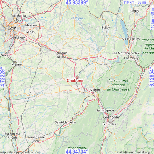
Châbons GPS coordinates[2]
45° 26' 34.152" North, 5° 25' 31.512" East
| Map corner | latitude | longitude |
|---|---|---|
| Upper-left | 45.93399°, | 4.72229° |
| Center: | 45.44282°, | 5.42542° |
| Lower-right: | 44.94734°, | 6.12854° |
| Map W x H: | 109.7×109.7 km | = 68.2×68.2mi |
| max Lat: | 51.07786° ⇑74.8% North |
| Châbons: | 45.44282° |
| min Lat: | ⇓25.2% South 41.3874° |
| min Long | Châbons | max Long |
| -5.08615° | 5.42542° | 9.52242° |
| W 82.2%⇐ | ⇒17.8% E |
Elevation
Elevation of Châbons is 451 m = 1480 ft, and this is 257.3 m = 844 ft above average elevation for this country.
| Max E: |
2333 m = 7654 ft | 8.9% |
| Châbons | 451 m 1480 ft | |
| Avg. | 193.7 m = 635 ft | |
Min E: |
-1 m = -3 ft | 91.1% |
See also: France elevation on elevation.city.
Geographical zone
Châbons is located in North temperate zone (between Tropic of Cancer and the Arctic Circle). Distance of this North polar circle is 2348.4 km =1459.2 mi to North.| Distance of | km | miles | from Châbons |
|---|---|---|---|
| North Pole | 4954.3 | 3078.5 | to North |
| Arctic Circle | 2348.4 | 1459.2 | to North |
| Tropic Cancer | 2446.8 | 1520.4 | to South |
| Equator | 5052.8 | 3139.7 | to South |


Nearby cities:
15 places around Châbons: (largest is in red/bold)
• Apprieu
7.8 km =4.8 mi,  131°
131°
• Bilieu
9.2 km =5.7 mi,  86°
86°
• Biol
6.2 km =3.9 mi,  330°
330°
• Bizonnes
3.7 km =2.3 mi,  287°
287°
• Bévenais
5.7 km =3.5 mi,  205°
205°
• Charavines
7.2 km =4.5 mi,  102°
102°
• Chélieu
8.6 km =5.3 mi,  27°
27°
• Colombe
5.2 km =3.2 mi,  154°
154°
• Doissin
6.7 km =4.2 mi,  354°
354°
• La Frette
7.9 km =4.9 mi,  220°
220°
• Le Grand-Lemps
5.2 km =3.2 mi,  184°
184°
• Le Pin
6.4 km =4 mi,  76°
76°
• Mottier
9.4 km =5.8 mi,  256°
256°
• Oyeu
4.5 km =2.8 mi,  121°
121°
• Virieu
6 km =3.7 mi,  40°
40°
Sources, notices
• [Note1] Compared only with cities in France existing in our database
• [Src1] Map data: © OpenStreetMap contributors (CC-BY-SA)
• [Src2] Other city data from geonames.org with taken over terms of usage.
• [Src3] Geographical zone / Annual Mean Temperature by Robert A. Rohde @ Wikipedia
