Lauwin-Planque geodata
Lauwin-Planque (Hauts-de-France) is a populated place; located in France in Europe/Paris (GMT+2) time zone. With population of 1,944 people, there are 4923 cities with bigger population in this country. Compared to other cities in France, 96.4% of cities are located further ↓South; 58.4% of cities are located further ←West and 91.6% of cities have higher elevation than Lauwin-Planque. Note1
Administrative division(s):
- Level 1: Hauts-de-France
- Level 2: Nord
- Level 3: Arrondissement de Douai
- Level 4: Lauwin-Planque


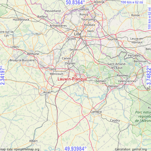
Lauwin-Planque GPS coordinates[2]
50° 23' 24.864" North, 3° 2' 42.36" East
| Map corner | latitude | longitude |
|---|---|---|
| Upper-left | 50.8364°, | 2.34197° |
| Center: | 50.39024°, | 3.0451° |
| Lower-right: | 49.93984°, | 3.74822° |
| Map W x H: | 99.7×99.7 km | = 62×62mi |
| max Lat: | 51.07786° ⇑3.6% North |
| Lauwin-Planque: | 50.39024° |
| min Lat: | ⇓96.4% South 41.3874° |
| min Long | Lauwin-Planque | max Long |
| -5.08615° | 3.0451° | 9.52242° |
| W 58.4%⇐ | ⇒41.6% E |
Elevation
Elevation of Lauwin-Planque is 26 m = 85 ft, and this is 167.7 m = 550 ft below average elevation for this country.
| Max E: |
2333 m = 7654 ft | 91.6% |
| Avg. | 193.7 m = 635 ft | |
| Lauwin-Planque | 26 m = 85 ft | |
Min E: |
-1 m = -3 ft | 8.4% |
See also: France elevation on elevation.city.
Geographical zone
Lauwin-Planque is located in North temperate zone (between Tropic of Cancer and the Arctic Circle). Distance of this North polar circle is 1798.3 km =1117.4 mi to North.| Distance of | km | miles | from Lauwin-Planque |
|---|---|---|---|
| North Pole | 4404.2 | 2736.6 | to North |
| Arctic Circle | 1798.3 | 1117.4 | to North |
| Tropic Cancer | 2997 | 1862.2 | to South |
| Equator | 5602.9 | 3481.5 | to South |


Nearby cities:
15 places around Lauwin-Planque: (largest is in red/bold)
• Auby
2.8 km =1.7 mi,  13°
13°
• Courcelles-lès-Lens
3.6 km =2.2 mi,  325°
325°
• Courchelettes
5.6 km =3.5 mi,  169°
169°
• Cuincy
1.3 km =0.8 mi,  155°
155°
• Douai
3.3 km =2.1 mi,  131°
131°
• Esquerchin
2.7 km =1.7 mi,  233°
233°
• Flers-en-Escrebieux
1.4 km =0.9 mi,  51°
51°
• Lambres-lez-Douai
4.7 km =2.9 mi, 161°
• Leforest
5.6 km =3.5 mi, 14°
• Noyelles-Godault
4.8 km =3 mi,  309°
309°
• Quiéry-la-Motte
5.5 km =3.4 mi,  240°
240°
• Raimbeaucourt
6 km =3.7 mi,  34°
34°
• Roost-Warendin
5.3 km =3.3 mi, 52°
• Waziers
5 km =3.1 mi,  93°
93°
• Évin-Malmaison
5.5 km =3.4 mi,  349°
349°
Sources, notices
• [Note1] Compared only with cities in France existing in our database
• [Src1] Map data: © OpenStreetMap contributors (CC-BY-SA)
• [Src2] Other city data from geonames.org with taken over terms of usage.
• [Src3] Geographical zone / Annual Mean Temperature by Robert A. Rohde @ Wikipedia
