Le Collet-de-Dèze geodata
Le Collet-de-Dèze (Occitanie) is a populated place; located in France in Europe/Paris (GMT+2) time zone. With population of 710 people, there are 11647 cities with bigger population in this country. Compared to other cities in France, 85.2% of cities are located further ↑North; 67.1% of cities are located further ←West and 80.7% of cities have lower elevation than Le Collet-de-Dèze. Note1
Administrative division(s):
- Level 1: Occitanie
- Level 2: Département de la Lozère
- Level 3: Arrondissement de Florac
- Level 4: Le Collet-de-Dèze


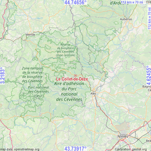
Le Collet-de-Dèze GPS coordinates[2]
44° 14' 42.072" North, 3° 55' 17.148" East
| Map corner | latitude | longitude |
|---|---|---|
| Upper-left | 44.74656°, | 3.2183° |
| Center: | 44.24502°, | 3.92143° |
| Lower-right: | 43.73917°, | 4.62455° |
| Map W x H: | 112×112 km | = 69.6×69.6mi |
| max Lat: | 51.07786° ⇑85.2% North |
| Le Collet-de-Dèze: | 44.24502° |
| min Lat: | ⇓14.8% South 41.3874° |
| min Long | Le Collet-de-D� | max Long |
| -5.08615° | 3.92143° | 9.52242° |
| W 67.1%⇐ | ⇒32.9% E |
Elevation
Elevation of Le Collet-de-Dèze is 298 m = 978 ft, and this is 104.3 m = 342 ft above average elevation for this country.
| Max E: |
2333 m = 7654 ft | 19.3% |
| Le Collet-de-Dèze | 298 m 978 ft | |
| Avg. | 193.7 m = 635 ft | |
Min E: |
-1 m = -3 ft | 80.7% |
See also: France elevation on elevation.city.
Geographical zone
Le Collet-de-Dèze is located in North temperate zone (between Tropic of Cancer and the Arctic Circle). Distance of this Northern Tropic circle is 2313.7 km =1437.7 mi to South.| Distance of | km | miles | from Le Collet-de-Dèze |
|---|---|---|---|
| North Pole | 5087.5 | 3161.2 | to North |
| Arctic Circle | 2481.6 | 1542 | to North |
| Tropic Cancer | 2313.7 | 1437.7 | to South |
| Equator | 4919.6 | 3056.9 | to South |


Nearby cities:
15 places around Le Collet-de-Dèze: (largest is in red/bold)
• Bessèges
14.9 km =9.3 mi,  69°
69°
• Branoux-les-Taillades
6.6 km =4.1 mi,  115°
115°
• Cendras
15.7 km =9.8 mi,  132°
132°
• Chamborigaud
7.8 km =4.8 mi,  30°
30°
• Génolhac
11.9 km =7.4 mi,  11°
11°
• Laval-Pradel
12.3 km =7.6 mi,  110°
110°
• Le Martinet
13.4 km =8.3 mi,  87°
87°
• Les Salles-du-Gardon
10.1 km =6.3 mi, 114°
• Mialet
15 km =9.3 mi,  173°
173°
• Saint-Florent-sur-Auzonnet
15.2 km =9.4 mi, 91°
• Saint-Jean-du-Gard
15.8 km =9.8 mi,  190°
190°
• Saint-Julien-les-Rosiers
16.8 km =10.4 mi, 117°
• Saint-Martin-de-Valgalgues
15.8 km =9.8 mi, 125°
• Saint-Étienne-Vallée-Française
10.8 km =6.7 mi,  215°
215°
• Vialas
10 km =6.2 mi,  348°
348°
Sources, notices
• [Note1] Compared only with cities in France existing in our database
• [Src1] Map data: © OpenStreetMap contributors (CC-BY-SA)
• [Src2] Other city data from geonames.org with taken over terms of usage.
• [Src3] Geographical zone / Annual Mean Temperature by Robert A. Rohde @ Wikipedia
