Génolhac geodata
Génolhac (Occitanie) is a populated place; located in France in Europe/Paris (GMT+2) time zone. With population of 921 people, there are 9479 cities with bigger population in this country. Compared to other cities in France, 84.6% of cities are located further ↑North; 67.4% of cities are located further ←West and 92.5% of cities have lower elevation than Génolhac. Note1
Administrative division(s):
- Level 1: Occitanie
- Level 2: Gard
- Level 3: Arrondissement d’Alès
- Level 4: Génolhac


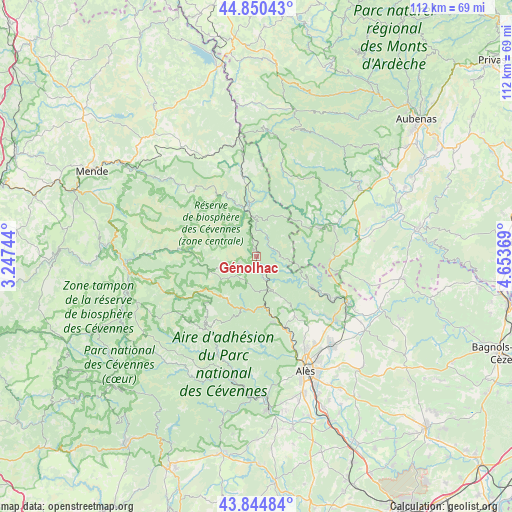
Génolhac GPS coordinates[2]
44° 20' 59.244" North, 3° 57' 2.016" East
| Map corner | latitude | longitude |
|---|---|---|
| Upper-left | 44.85043°, | 3.24744° |
| Center: | 44.34979°, | 3.95056° |
| Lower-right: | 43.84484°, | 4.65369° |
| Map W x H: | 111.8×111.8 km | = 69.5×69.5mi |
| max Lat: | 51.07786° ⇑84.6% North |
| Génolhac: | 44.34979° |
| min Lat: | ⇓15.4% South 41.3874° |
| min Long | Génolhac | max Long |
| -5.08615° | 3.95056° | 9.52242° |
| W 67.4%⇐ | ⇒32.6% E |
Elevation
Elevation of Génolhac is 490 m = 1608 ft, and this is 296.3 m = 972 ft above average elevation for this country.
| Max E: |
2333 m = 7654 ft | 7.5% |
| Génolhac | 490 m 1608 ft | |
| Avg. | 193.7 m = 635 ft | |
Min E: |
-1 m = -3 ft | 92.5% |
See also: France elevation on elevation.city.
Geographical zone
Génolhac is located in North temperate zone (between Tropic of Cancer and the Arctic Circle). Distance of this Northern Tropic circle is 2325.3 km =1444.9 mi to South.| Distance of | km | miles | from Génolhac |
|---|---|---|---|
| North Pole | 5075.8 | 3154 | to North |
| Arctic Circle | 2469.9 | 1534.7 | to North |
| Tropic Cancer | 2325.3 | 1444.9 | to South |
| Equator | 4931.2 | 3064.1 | to South |


Nearby cities:
15 places around Génolhac: (largest is in red/bold)
• Banne
16.4 km =10.2 mi,  83°
83°
• Bessèges
13.3 km =8.3 mi,  118°
118°
• Branoux-les-Taillades
15 km =9.3 mi,  165°
165°
• Chambonas
16 km =9.9 mi,  62°
62°
• Chamborigaud
5.2 km =3.2 mi,  161°
161°
• Gagnières
15 km =9.3 mi,  108°
108°
• Le Collet-de-Dèze
11.9 km =7.4 mi,  191°
191°
• Le Martinet
15.6 km =9.7 mi,  135°
135°
• Les Salles-du-Gardon
17.2 km =10.7 mi, 156°
• Les Vans
15.7 km =9.8 mi,  66°
66°
• Robiac-Rochessadoule
17.2 km =10.7 mi, 122°
• Saint-Florent-sur-Auzonnet
17.7 km =11 mi,  133°
133°
• Saint-Paul-le-Jeune
16.2 km =10.1 mi,  93°
93°
• Vialas
4.6 km =2.9 mi,  246°
246°
• Villefort
10 km =6.2 mi,  351°
351°
Sources, notices
• [Note1] Compared only with cities in France existing in our database
• [Src1] Map data: © OpenStreetMap contributors (CC-BY-SA)
• [Src2] Other city data from geonames.org with taken over terms of usage.
• [Src3] Geographical zone / Annual Mean Temperature by Robert A. Rohde @ Wikipedia
