Vialas geodata
Vialas (Occitanie) is a populated place; located in France in Europe/Paris (GMT+2) time zone. With population of 515 people, there are 14927 cities with bigger population in this country. Compared to other cities in France, 84.7% of cities are located further ↑North; 66.9% of cities are located further ←West and 95.2% of cities have lower elevation than Vialas. Note1
Administrative division(s):
- Level 1: Occitanie
- Level 2: Département de la Lozère
- Level 3: Arrondissement de Florac
- Level 4: Vialas


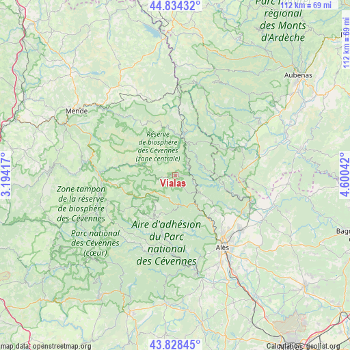
Vialas GPS coordinates[2]
44° 20' 0.744" North, 3° 53' 50.244" East
| Map corner | latitude | longitude |
|---|---|---|
| Upper-left | 44.83432°, | 3.19417° |
| Center: | 44.33354°, | 3.89729° |
| Lower-right: | 43.82845°, | 4.60042° |
| Map W x H: | 111.8×111.8 km | = 69.5×69.5mi |
| max Lat: | 51.07786° ⇑84.7% North |
| Vialas: | 44.33354° |
| min Lat: | ⇓15.3% South 41.3874° |
| min Long | Vialas | max Long |
| -5.08615° | 3.89729° | 9.52242° |
| W 66.9%⇐ | ⇒33.1% E |
Elevation
Elevation of Vialas is 597 m = 1959 ft, and this is 403.3 m = 1323 ft above average elevation for this country.
| Max E: |
2333 m = 7654 ft | 4.8% |
| Vialas | 597 m 1959 ft | |
| Avg. | 193.7 m = 635 ft | |
Min E: |
-1 m = -3 ft | 95.2% |
See also: France elevation on elevation.city.
Geographical zone
Vialas is located in North temperate zone (between Tropic of Cancer and the Arctic Circle). Distance of this Northern Tropic circle is 2323.5 km =1443.8 mi to South.| Distance of | km | miles | from Vialas |
|---|---|---|---|
| North Pole | 5077.6 | 3155.1 | to North |
| Arctic Circle | 2471.7 | 1535.8 | to North |
| Tropic Cancer | 2323.5 | 1443.8 | to South |
| Equator | 4929.4 | 3063 | to South |


Nearby cities:
15 places around Vialas: (largest is in red/bold)
• Bessèges
16.5 km =10.3 mi,  106°
106°
• Branoux-les-Taillades
14.9 km =9.3 mi,  148°
148°
• Chamborigaud
6.7 km =4.2 mi,  117°
117°
• Gagnières
18.7 km =11.6 mi,  99°
99°
• Génolhac
4.6 km =2.9 mi,  66°
66°
• Laval-Pradel
19.5 km =12.1 mi,  136°
136°
• Le Collet-de-Dèze
10 km =6.2 mi,  168°
168°
• Le Martinet
17.8 km =11.1 mi, 121°
• Les Salles-du-Gardon
17.9 km =11.1 mi, 141°
• Les Vans
20.3 km =12.6 mi, 66°
• Robiac-Rochessadoule
20.2 km =12.6 mi, 111°
• Saint-Florent-sur-Auzonnet
20 km =12.4 mi, 121°
• Saint-Paul-le-Jeune
20.4 km =12.7 mi,  87°
87°
• Saint-Étienne-Vallée-Française
19.1 km =11.9 mi,  193°
193°
• Villefort
12 km =7.5 mi,  13°
13°
Sources, notices
• [Note1] Compared only with cities in France existing in our database
• [Src1] Map data: © OpenStreetMap contributors (CC-BY-SA)
• [Src2] Other city data from geonames.org with taken over terms of usage.
• [Src3] Geographical zone / Annual Mean Temperature by Robert A. Rohde @ Wikipedia
