Lau-Balagnas geodata
Lau-Balagnas (Occitanie) is a populated place; located in France in Europe/Paris (GMT+2) time zone. With population of 514 people, there are 14947 cities with bigger population in this country. Compared to other cities in France, 98.3% of cities are located further ↑North; 78.8% of cities are located further →East and 90% of cities have lower elevation than Lau-Balagnas. Note1
Administrative division(s):
- Level 1: Occitanie
- Level 2: Département des Hautes-Pyrénées
- Level 3: Arrondissement d’Argelès-Gazost
- Level 4: Lau-Balagnas


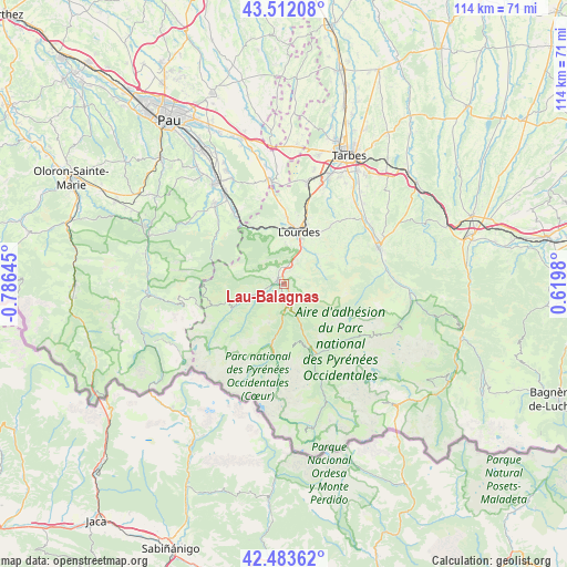
Lau-Balagnas GPS coordinates[2]
43° 0' 0" North, 0° 4' 59.988" West
| Map corner | latitude | longitude |
|---|---|---|
| Upper-left | 43.51208°, | -0.78645° |
| Center: | 43°, | -0.08333° |
| Lower-right: | 42.48362°, | 0.6198° |
| Map W x H: | 114.4×114.4 km | = 71.1×71.1mi |
| max Lat: | 51.07786° ⇑98.3% North |
| Lau-Balagnas: | 43° |
| min Lat: | ⇓1.7% South 41.3874° |
| min Long | Lau-Balagnas | max Long |
| -5.08615° | -0.08333° | 9.52242° |
| W 21.2%⇐ | ⇒78.8% E |
Elevation
Elevation of Lau-Balagnas is 425 m = 1394 ft, and this is 231.3 m = 759 ft above average elevation for this country.
| Max E: |
2333 m = 7654 ft | 10% |
| Lau-Balagnas | 425 m 1394 ft | |
| Avg. | 193.7 m = 635 ft | |
Min E: |
-1 m = -3 ft | 90% |
See also: France elevation on elevation.city.
Geographical zone
Lau-Balagnas is located in North temperate zone (between Tropic of Cancer and the Arctic Circle). Distance of this Northern Tropic circle is 2175.2 km =1351.6 mi to South.| Distance of | km | miles | from Lau-Balagnas |
|---|---|---|---|
| North Pole | 5225.9 | 3247.2 | to North |
| Arctic Circle | 2620 | 1628 | to North |
| Tropic Cancer | 2175.2 | 1351.6 | to South |
| Equator | 4781.2 | 2970.9 | to South |


Nearby cities:
15 places around Lau-Balagnas: (largest is in red/bold)
• Adé
15.4 km =9.6 mi,  15°
15°
• Argelès-Gazost
1.3 km =0.8 mi,  283°
283°
• Arras-en-Lavedan
4.5 km =2.8 mi,  245°
245°
• Arrens-Marsous
12.2 km =7.6 mi,  242°
242°
• Arthez-d’Asson
16.4 km =10.2 mi,  304°
304°
• Bénac
19.2 km =11.9 mi,  27°
27°
• Cauterets
13.3 km =8.3 mi,  191°
191°
• Lanne
19.9 km =12.4 mi, 23°
• Lestelle-Bétharram
18.4 km =11.4 mi,  323°
323°
• Lourdes
11.4 km =7.1 mi,  13°
13°
• Luz-Saint-Sauveur
15.7 km =9.8 mi,  155°
155°
• Montaut
17.6 km =10.9 mi,  327°
327°
• Pierrefitte-Nestalas
3.9 km =2.4 mi, 159°
• Poueyferré
13 km =8.1 mi, 5°
• Saint-Pé-de-Bigorre
13.1 km =8.1 mi, 331°
Sources, notices
• [Note1] Compared only with cities in France existing in our database
• [Src1] Map data: © OpenStreetMap contributors (CC-BY-SA)
• [Src2] Other city data from geonames.org with taken over terms of usage.
• [Src3] Geographical zone / Annual Mean Temperature by Robert A. Rohde @ Wikipedia
