Tautavel geodata
Tautavel (Occitanie) is a populated place; located in France in Europe/Paris (GMT+2) time zone. With population of 928 people, there are 9405 cities with bigger population in this country. Compared to other cities in France, 98.8% of cities are located further ↑North; 54.2% of cities are located further ←West and 56.9% of cities have higher elevation than Tautavel. Note1
Administrative division(s):
- Level 1: Occitanie
- Level 2: Département des Pyrénées-Orientales
- Level 3: Arrondissement de Perpignan
- Level 4: Tautavel


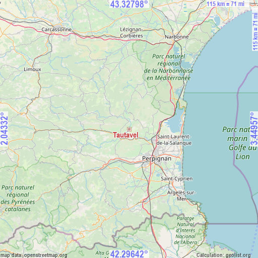
Tautavel GPS coordinates[2]
42° 48' 51.66" North, 2° 44' 47.184" East
| Map corner | latitude | longitude |
|---|---|---|
| Upper-left | 43.32798°, | 2.04332° |
| Center: | 42.81435°, | 2.74644° |
| Lower-right: | 42.29642°, | 3.44957° |
| Map W x H: | 114.7×114.7 km | = 71.3×71.3mi |
| max Lat: | 51.07786° ⇑98.8% North |
| Tautavel: | 42.81435° |
| min Lat: | ⇓1.2% South 41.3874° |
| min Long | Tautavel | max Long |
| -5.08615° | 2.74644° | 9.52242° |
| W 54.2%⇐ | ⇒45.8% E |
Elevation
Elevation of Tautavel is 111 m = 364 ft, and this is 82.7 m = 271 ft below average elevation for this country.
| Max E: |
2333 m = 7654 ft | 56.9% |
| Avg. | 193.7 m = 635 ft | |
| Tautavel | 111 m = 364 ft | |
Min E: |
-1 m = -3 ft | 43.1% |
See also: France elevation on elevation.city.
Geographical zone
Tautavel is located in North temperate zone (between Tropic of Cancer and the Arctic Circle). Distance of this Northern Tropic circle is 2154.6 km =1338.8 mi to South.| Distance of | km | miles | from Tautavel |
|---|---|---|---|
| North Pole | 5246.6 | 3260.1 | to North |
| Arctic Circle | 2640.7 | 1640.9 | to North |
| Tropic Cancer | 2154.6 | 1338.8 | to South |
| Equator | 4760.5 | 2958 | to South |


Nearby cities:
15 places around Tautavel: (largest is in red/bold)
• Baixas
8.9 km =5.5 mi,  144°
144°
• Cases-de-Pène
5.2 km =3.2 mi, 140°
• Corneilla-la-Rivière
13.1 km =8.1 mi,  185°
185°
• Estagel
6.1 km =3.8 mi,  221°
221°
• Latour-de-France
9.2 km =5.7 mi,  235°
235°
• Maury
12.5 km =7.8 mi,  268°
268°
• Opoul-Périllos
12.6 km =7.8 mi,  62°
62°
• Paziols
5.4 km =3.4 mi,  335°
335°
• Peyrestortes
10.9 km =6.8 mi,  127°
127°
• Pézilla-la-Rivière
13.4 km =8.3 mi,  171°
171°
• Rivesaltes
11.4 km =7.1 mi,  115°
115°
• Saint-Estève
14 km =8.7 mi, 144°
• Salses-le-Château
14 km =8.7 mi,  81°
81°
• Tuchan
8.5 km =5.3 mi, 344°
• Vingrau
4.6 km =2.9 mi,  34°
34°
Sources, notices
• [Note1] Compared only with cities in France existing in our database
• [Src1] Map data: © OpenStreetMap contributors (CC-BY-SA)
• [Src2] Other city data from geonames.org with taken over terms of usage.
• [Src3] Geographical zone / Annual Mean Temperature by Robert A. Rohde @ Wikipedia
