Laons geodata
Laons (Centre) is a populated place; located in France in Europe/Paris (GMT+2) time zone. With population of 687 people, there are 11986 cities with bigger population in this country. Compared to other cities in France, 73.3% of cities are located further ↓South; 67% of cities are located further →East and 58.3% of cities have lower elevation than Laons. Note1
Administrative division(s):
- Level 1: Centre
- Level 2: Département d'Eure-et-Loir
- Level 3: Arrondissement de Dreux
- Level 4: Laons


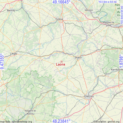
Laons GPS coordinates[2]
48° 42' 16.452" North, 1° 10' 36.012" East
| Map corner | latitude | longitude |
|---|---|---|
| Upper-left | 49.16645°, | 0.47355° |
| Center: | 48.70457°, | 1.17667° |
| Lower-right: | 48.23841°, | 1.8798° |
| Map W x H: | 103.2×103.2 km | = 64.1×64.1mi |
| max Lat: | 51.07786° ⇑26.7% North |
| Laons: | 48.70457° |
| min Lat: | ⇓73.3% South 41.3874° |
| min Long | Laons | max Long |
| -5.08615° | 1.17667° | 9.52242° |
| W 33%⇐ | ⇒67% E |
Elevation
Elevation of Laons is 162 m = 531 ft, and this is 31.7 m = 104 ft below average elevation for this country.
| Max E: |
2333 m = 7654 ft | 41.7% |
| Avg. | 193.7 m = 635 ft | |
| Laons | 162 m = 531 ft | |
Min E: |
-1 m = -3 ft | 58.3% |
See also: France elevation on elevation.city.
Geographical zone
Laons is located in North temperate zone (between Tropic of Cancer and the Arctic Circle). Distance of this North polar circle is 1985.7 km =1233.9 mi to North.| Distance of | km | miles | from Laons |
|---|---|---|---|
| North Pole | 4591.6 | 2853.1 | to North |
| Arctic Circle | 1985.7 | 1233.9 | to North |
| Tropic Cancer | 2809.5 | 1745.7 | to South |
| Equator | 5415.4 | 3365 | to South |


Nearby cities:
15 places around Laons: (largest is in red/bold)
• Aunay-sous-Crécy
10 km =6.2 mi,  112°
112°
• Brezolles
7.7 km =4.8 mi,  258°
258°
• Dampierre-sur-Avre
6.7 km =4.2 mi,  342°
342°
• Garnay
11.8 km =7.3 mi,  89°
89°
• La Madeleine-de-Nonancourt
7.8 km =4.8 mi,  13°
13°
• Maillebois
8.5 km =5.3 mi,  193°
193°
• Mesnil-sur-l’Estrée
11.7 km =7.3 mi,  51°
51°
• Nonancourt
7.5 km =4.7 mi, 11°
• Saint-Germain-sur-Avre
9.4 km =5.8 mi,  44°
44°
• Saint-Lubin-des-Joncherets
7.5 km =4.7 mi,  23°
23°
• Saint-Rémy-sur-Avre
8.1 km =5 mi, 38°
• Saulnières
8.6 km =5.3 mi,  125°
125°
• Tillières-sur-Avre
10.7 km =6.6 mi,  302°
302°
• Tréon
11.4 km =7.1 mi, 105°
• Vert-en-Drouais
10.6 km =6.6 mi, 54°
Sources, notices
• [Note1] Compared only with cities in France existing in our database
• [Src1] Map data: © OpenStreetMap contributors (CC-BY-SA)
• [Src2] Other city data from geonames.org with taken over terms of usage.
• [Src3] Geographical zone / Annual Mean Temperature by Robert A. Rohde @ Wikipedia
