Garnay geodata
Garnay (Centre) is a populated place; located in France in Europe/Paris (GMT+2) time zone. With population of 1,028 people, there are 8631 cities with bigger population in this country. Compared to other cities in France, 73.4% of cities are located further ↓South; 65.2% of cities are located further →East and 60% of cities have higher elevation than Garnay. Note1
Administrative division(s):
- Level 1: Centre
- Level 2: Département d'Eure-et-Loir
- Level 3: Arrondissement de Dreux
- Level 4: Garnay


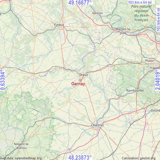
Garnay GPS coordinates[2]
48° 42' 17.604" North, 1° 20' 13.416" East
| Map corner | latitude | longitude |
|---|---|---|
| Upper-left | 49.16677°, | 0.63394° |
| Center: | 48.70489°, | 1.33706° |
| Lower-right: | 48.23873°, | 2.04019° |
| Map W x H: | 103.2×103.2 km | = 64.1×64.1mi |
| max Lat: | 51.07786° ⇑26.6% North |
| Garnay: | 48.70489° |
| min Lat: | ⇓73.4% South 41.3874° |
| min Long | Garnay | max Long |
| -5.08615° | 1.33706° | 9.52242° |
| W 34.8%⇐ | ⇒65.2% E |
Elevation
Elevation of Garnay is 102 m = 335 ft, and this is 91.7 m = 301 ft below average elevation for this country.
| Max E: |
2333 m = 7654 ft | 60% |
| Avg. | 193.7 m = 635 ft | |
| Garnay | 102 m = 335 ft | |
Min E: |
-1 m = -3 ft | 40% |
See also: France elevation on elevation.city.
Geographical zone
Garnay is located in North temperate zone (between Tropic of Cancer and the Arctic Circle). Distance of this North polar circle is 1985.7 km =1233.9 mi to North.| Distance of | km | miles | from Garnay |
|---|---|---|---|
| North Pole | 4591.6 | 2853.1 | to North |
| Arctic Circle | 1985.7 | 1233.9 | to North |
| Tropic Cancer | 2809.6 | 1745.8 | to South |
| Equator | 5415.5 | 3365 | to South |


Nearby cities:
15 places around Garnay: (largest is in red/bold)
• Aunay-sous-Crécy
4.7 km =2.9 mi,  212°
212°
• Charpont
7.3 km =4.5 mi,  95°
95°
• Dreux
4.1 km =2.5 mi,  30°
30°
• Luray
4.9 km =3 mi,  69°
69°
• Marville-Moutiers-Brûlé
6.3 km =3.9 mi,  132°
132°
• Mesnil-sur-l’Estrée
7.7 km =4.8 mi,  340°
340°
• Montreuil
8.4 km =5.2 mi,  16°
16°
• Muzy
7.7 km =4.8 mi,  5°
5°
• Mézières-en-Drouais
6.8 km =4.2 mi, 71°
• Saint-Germain-sur-Avre
8.4 km =5.2 mi,  322°
322°
• Sainte-Gemme-Moronval
6.8 km =4.2 mi,  56°
56°
• Saulnières
7 km =4.3 mi,  223°
223°
• Tréon
3.2 km =2 mi,  193°
193°
• Vernouillet
3 km =1.9 mi,  53°
53°
• Vert-en-Drouais
6.9 km =4.3 mi,  333°
333°
Sources, notices
• [Note1] Compared only with cities in France existing in our database
• [Src1] Map data: © OpenStreetMap contributors (CC-BY-SA)
• [Src2] Other city data from geonames.org with taken over terms of usage.
• [Src3] Geographical zone / Annual Mean Temperature by Robert A. Rohde @ Wikipedia
