Lanta geodata
Lanta (Occitanie) is a populated place; located in France in Europe/Paris (GMT+2) time zone. With population of 1,373 people, there are 6715 cities with bigger population in this country. Compared to other cities in France, 92.2% of cities are located further ↑North; 60.8% of cities are located further →East and 67.8% of cities have lower elevation than Lanta. Note1
Administrative division(s):
- Level 1: Occitanie
- Level 2: Haute-Garonne
- Level 3: Arrondissement de Toulouse
- Level 4: Lanta


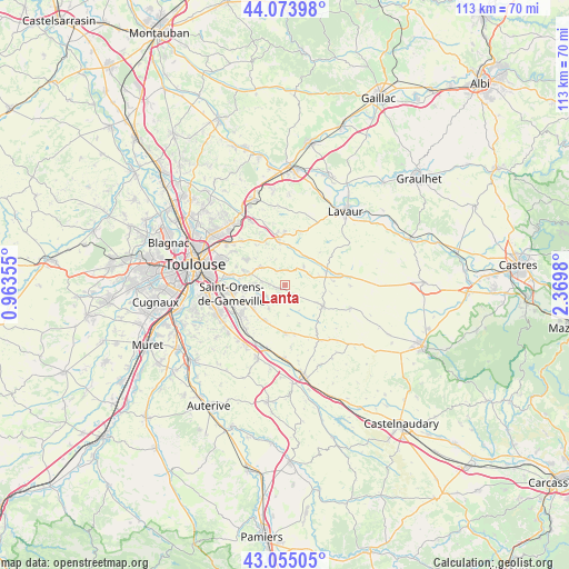
Lanta GPS coordinates[2]
43° 34' 0.012" North, 1° 40' 0.012" East
| Map corner | latitude | longitude |
|---|---|---|
| Upper-left | 44.07398°, | 0.96355° |
| Center: | 43.56667°, | 1.66667° |
| Lower-right: | 43.05505°, | 2.3698° |
| Map W x H: | 113.3×113.3 km | = 70.4×70.4mi |
| max Lat: | 51.07786° ⇑92.2% North |
| Lanta: | 43.56667° |
| min Lat: | ⇓7.8% South 41.3874° |
| min Long | Lanta | max Long |
| -5.08615° | 1.66667° | 9.52242° |
| W 39.2%⇐ | ⇒60.8% E |
Elevation
Elevation of Lanta is 208 m = 682 ft, and this is 14.3 m = 47 ft above average elevation for this country.
| Max E: |
2333 m = 7654 ft | 32.2% |
| Lanta | 208 m 682 ft | |
| Avg. | 193.7 m = 635 ft | |
Min E: |
-1 m = -3 ft | 67.8% |
See also: France elevation on elevation.city.
Geographical zone
Lanta is located in North temperate zone (between Tropic of Cancer and the Arctic Circle). Distance of this Northern Tropic circle is 2238.2 km =1390.8 mi to South.| Distance of | km | miles | from Lanta |
|---|---|---|---|
| North Pole | 5162.9 | 3208.1 | to North |
| Arctic Circle | 2557 | 1588.8 | to North |
| Tropic Cancer | 2238.2 | 1390.8 | to South |
| Equator | 4844.2 | 3010 | to South |


Nearby cities:
15 places around Lanta: (largest is in red/bold)
• Aigrefeuille
6.2 km =3.9 mi,  271°
271°
• Auzielle
8.6 km =5.3 mi,  251°
251°
• Belberaud
10.5 km =6.5 mi,  229°
229°
• Bourg-Saint-Bernard
5.2 km =3.2 mi,  44°
44°
• Caraman
8.4 km =5.2 mi,  116°
116°
• Drémil-Lafage
6.2 km =3.9 mi,  301°
301°
• Escalquens
10.3 km =6.4 mi,  237°
237°
• Flourens
8.9 km =5.5 mi,  289°
289°
• Fourquevaux
8 km =5 mi,  212°
212°
• Labastide-Beauvoir
9.5 km =5.9 mi,  180°
180°
• Lauzerville
8.3 km =5.2 mi,  261°
261°
• Lavalette
9.7 km =6 mi,  324°
324°
• Mons
9.2 km =5.7 mi, 303°
• Odars
7.9 km =4.9 mi, 232°
• Verfeil
10.1 km =6.3 mi,  358°
358°
Sources, notices
• [Note1] Compared only with cities in France existing in our database
• [Src1] Map data: © OpenStreetMap contributors (CC-BY-SA)
• [Src2] Other city data from geonames.org with taken over terms of usage.
• [Src3] Geographical zone / Annual Mean Temperature by Robert A. Rohde @ Wikipedia
