Lanquetot geodata
Lanquetot (Normandy) is a populated place; located in France in Europe/Paris (GMT+2) time zone. With population of 1,034 people, there are 8580 cities with bigger population in this country. Compared to other cities in France, 90.4% of cities are located further ↓South; 73.2% of cities are located further →East and 52.8% of cities have lower elevation than Lanquetot. Note1
Administrative division(s):
- Level 1: Normandy
- Level 2: Seine-Maritime
- Level 3: Arrondissement du Havre
- Level 4: Lanquetot


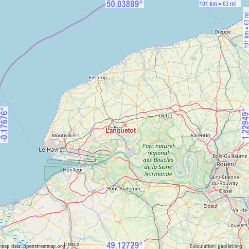
Lanquetot GPS coordinates[2]
49° 35' 6.972" North, 0° 31' 34.932" East
| Map corner | latitude | longitude |
|---|---|---|
| Upper-left | 50.03899°, | -0.17676° |
| Center: | 49.58527°, | 0.52637° |
| Lower-right: | 49.12729°, | 1.22949° |
| Map W x H: | 101.4×101.4 km | = 63×63mi |
| max Lat: | 51.07786° ⇑9.6% North |
| Lanquetot: | 49.58527° |
| min Lat: | ⇓90.4% South 41.3874° |
| min Long | Lanquetot | max Long |
| -5.08615° | 0.52637° | 9.52242° |
| W 26.8%⇐ | ⇒73.2% E |
Elevation
Elevation of Lanquetot is 142 m = 466 ft, and this is 51.7 m = 170 ft below average elevation for this country.
| Max E: |
2333 m = 7654 ft | 47.2% |
| Avg. | 193.7 m = 635 ft | |
| Lanquetot | 142 m = 466 ft | |
Min E: |
-1 m = -3 ft | 52.8% |
See also: France elevation on elevation.city.
Geographical zone
Lanquetot is located in North temperate zone (between Tropic of Cancer and the Arctic Circle). Distance of this North polar circle is 1887.8 km =1173 mi to North.| Distance of | km | miles | from Lanquetot |
|---|---|---|---|
| North Pole | 4493.7 | 2792.3 | to North |
| Arctic Circle | 1887.8 | 1173 | to North |
| Tropic Cancer | 2907.4 | 1806.6 | to South |
| Equator | 5513.4 | 3425.9 | to South |


Nearby cities:
15 places around Lanquetot: (largest is in red/bold)
• Bernières
5.3 km =3.3 mi,  319°
319°
• Beuzeville-la-Grenier
7.2 km =4.5 mi,  275°
275°
• Beuzevillette
1.7 km =1.1 mi,  153°
153°
• Bolbec
4 km =2.5 mi,  250°
250°
• Bolleville
3.2 km =2 mi,  60°
60°
• Grand-Camp
5.7 km =3.5 mi,  133°
133°
• Gruchet-le-Valasse
4.4 km =2.7 mi,  219°
219°
• La Trinité-du-Mont
5.1 km =3.2 mi,  157°
157°
• Nointot
3.9 km =2.4 mi,  291°
291°
• Rouville
4.1 km =2.5 mi,  331°
331°
• Saint-Antoine-la-Forêt
6.6 km =4.1 mi,  214°
214°
• Saint-Eustache-la-Forêt
6.3 km =3.9 mi,  233°
233°
• Saint-Jean-de-Folleville
7.2 km =4.5 mi,  192°
192°
• Trouville
5.5 km =3.4 mi,  104°
104°
• Yébleron
5.4 km =3.4 mi,  8°
8°
Sources, notices
• [Note1] Compared only with cities in France existing in our database
• [Src1] Map data: © OpenStreetMap contributors (CC-BY-SA)
• [Src2] Other city data from geonames.org with taken over terms of usage.
• [Src3] Geographical zone / Annual Mean Temperature by Robert A. Rohde @ Wikipedia
