Nointot geodata
Nointot (Normandy) is a populated place; located in France in Europe/Paris (GMT+2) time zone. With population of 1,113 people, there are 8050 cities with bigger population in this country. Compared to other cities in France, 90.5% of cities are located further ↓South; 73.6% of cities are located further →East and 52.2% of cities have lower elevation than Nointot. Note1
Administrative division(s):
- Level 1: Normandy
- Level 2: Seine-Maritime
- Level 3: Arrondissement du Havre
- Level 4: Nointot


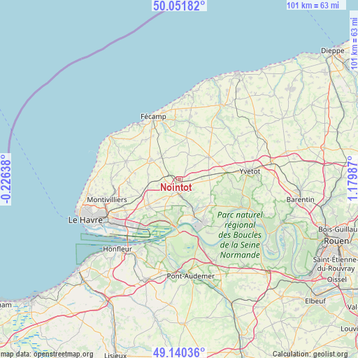
Nointot GPS coordinates[2]
49° 35' 53.592" North, 0° 28' 36.264" East
| Map corner | latitude | longitude |
|---|---|---|
| Upper-left | 50.05182°, | -0.22638° |
| Center: | 49.59822°, | 0.47674° |
| Lower-right: | 49.14036°, | 1.17987° |
| Map W x H: | 101.3×101.3 km | = 62.9×62.9mi |
| max Lat: | 51.07786° ⇑9.5% North |
| Nointot: | 49.59822° |
| min Lat: | ⇓90.5% South 41.3874° |
| min Long | Nointot | max Long |
| -5.08615° | 0.47674° | 9.52242° |
| W 26.4%⇐ | ⇒73.6% E |
Elevation
Elevation of Nointot is 140 m = 459 ft, and this is 53.7 m = 176 ft below average elevation for this country.
| Max E: |
2333 m = 7654 ft | 47.8% |
| Avg. | 193.7 m = 635 ft | |
| Nointot | 140 m = 459 ft | |
Min E: |
-1 m = -3 ft | 52.2% |
See also: France elevation on elevation.city.
Geographical zone
Nointot is located in North temperate zone (between Tropic of Cancer and the Arctic Circle). Distance of this North polar circle is 1886.4 km =1172.2 mi to North.| Distance of | km | miles | from Nointot |
|---|---|---|---|
| North Pole | 4492.3 | 2791.4 | to North |
| Arctic Circle | 1886.4 | 1172.2 | to North |
| Tropic Cancer | 2908.9 | 1807.5 | to South |
| Equator | 5514.8 | 3426.7 | to South |


Nearby cities:
15 places around Nointot: (largest is in red/bold)
• Bernières
2.6 km =1.6 mi,  2°
2°
• Beuzeville-la-Grenier
3.7 km =2.3 mi,  258°
258°
• Beuzevillette
5.3 km =3.3 mi,  124°
124°
• Bolbec
2.8 km =1.7 mi,  184°
184°
• Bolleville
6.4 km =4 mi,  88°
88°
• Bréauté
6.4 km =4 mi,  300°
300°
• Gruchet-le-Valasse
4.9 km =3 mi,  171°
171°
• Lanquetot
3.9 km =2.4 mi,  111°
111°
• Les Trois-Pierres
6.9 km =4.3 mi,  218°
218°
• Mélamare
7 km =4.3 mi,  192°
192°
• Rouville
2.7 km =1.7 mi,  37°
37°
• Saint-Antoine-la-Forêt
6.9 km =4.3 mi, 181°
• Saint-Eustache-la-Forêt
5.4 km =3.4 mi,  196°
196°
• Vattetot-sous-Beaumont
3.7 km =2.3 mi,  323°
323°
• Yébleron
5.9 km =3.7 mi,  48°
48°
Sources, notices
• [Note1] Compared only with cities in France existing in our database
• [Src1] Map data: © OpenStreetMap contributors (CC-BY-SA)
• [Src2] Other city data from geonames.org with taken over terms of usage.
• [Src3] Geographical zone / Annual Mean Temperature by Robert A. Rohde @ Wikipedia
