Beuzevillette geodata
Beuzevillette (Normandy) is a populated place; located in France in Europe/Paris (GMT+2) time zone. With population of 667 people, there are 12267 cities with bigger population in this country. Compared to other cities in France, 90.2% of cities are located further ↓South; 73.1% of cities are located further →East and 51.7% of cities have lower elevation than Beuzevillette. Note1
Administrative division(s):
- Level 1: Normandy
- Level 2: Seine-Maritime
- Level 3: Arrondissement du Havre
- Level 4: Beuzevillette


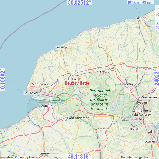
Beuzevillette GPS coordinates[2]
49° 34' 16.572" North, 0° 32' 13.56" East
| Map corner | latitude | longitude |
|---|---|---|
| Upper-left | 50.02512°, | -0.16602° |
| Center: | 49.57127°, | 0.5371° |
| Lower-right: | 49.11316°, | 1.24023° |
| Map W x H: | 101.4×101.4 km | = 63×63mi |
| max Lat: | 51.07786° ⇑9.8% North |
| Beuzevillette: | 49.57127° |
| min Lat: | ⇓90.2% South 41.3874° |
| min Long | Beuzevillette | max Long |
| -5.08615° | 0.5371° | 9.52242° |
| W 26.9%⇐ | ⇒73.1% E |
Elevation
Elevation of Beuzevillette is 138 m = 453 ft, and this is 55.7 m = 183 ft below average elevation for this country.
| Max E: |
2333 m = 7654 ft | 48.3% |
| Avg. | 193.7 m = 635 ft | |
| Beuzevillette | 138 m = 453 ft | |
Min E: |
-1 m = -3 ft | 51.7% |
See also: France elevation on elevation.city.
Geographical zone
Beuzevillette is located in North temperate zone (between Tropic of Cancer and the Arctic Circle). Distance of this North polar circle is 1889.4 km =1174 mi to North.| Distance of | km | miles | from Beuzevillette |
|---|---|---|---|
| North Pole | 4495.3 | 2793.2 | to North |
| Arctic Circle | 1889.4 | 1174 | to North |
| Tropic Cancer | 2905.9 | 1805.6 | to South |
| Equator | 5511.8 | 3424.9 | to South |


Nearby cities:
15 places around Beuzevillette: (largest is in red/bold)
• Auberville-la-Campagne
6.2 km =3.9 mi,  133°
133°
• Bolbec
4.6 km =2.9 mi,  272°
272°
• Bolleville
3.7 km =2.3 mi,  32°
32°
• Grand-Camp
4.1 km =2.5 mi, 125°
• Gruchet-le-Valasse
4.1 km =2.5 mi,  243°
243°
• La Trinité-du-Mont
3.4 km =2.1 mi,  159°
159°
• Lanquetot
1.7 km =1.1 mi,  333°
333°
• Lillebonne
5.7 km =3.5 mi,  180°
180°
• Nointot
5.3 km =3.3 mi,  304°
304°
• Rouville
5.8 km =3.6 mi, 332°
• Saint-Antoine-la-Forêt
6 km =3.7 mi,  229°
229°
• Saint-Eustache-la-Forêt
6.3 km =3.9 mi,  249°
249°
• Saint-Jean-de-Folleville
6 km =3.7 mi,  202°
202°
• Trouville
4.6 km =2.9 mi,  88°
88°
• Yébleron
6.9 km =4.3 mi,  0°
0°
Sources, notices
• [Note1] Compared only with cities in France existing in our database
• [Src1] Map data: © OpenStreetMap contributors (CC-BY-SA)
• [Src2] Other city data from geonames.org with taken over terms of usage.
• [Src3] Geographical zone / Annual Mean Temperature by Robert A. Rohde @ Wikipedia
