Gruchet-le-Valasse geodata
Gruchet-le-Valasse (Normandy) is a populated place; located in France in Europe/Paris (GMT+2) time zone. With population of 2,788 people, there are 3505 cities with bigger population in this country. Compared to other cities in France, 90.1% of cities are located further ↓South; 73.5% of cities are located further →East and 91.6% of cities have higher elevation than Gruchet-le-Valasse. Note1
Administrative division(s):
- Level 1: Normandy
- Level 2: Seine-Maritime
- Level 3: Arrondissement du Havre
- Level 4: Gruchet-le-Valasse


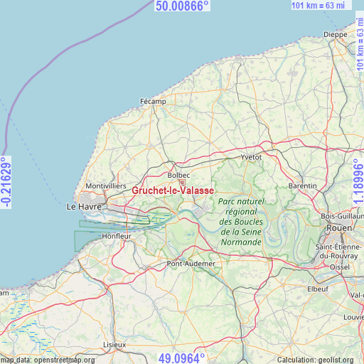
Gruchet-le-Valasse GPS coordinates[2]
49° 33' 16.776" North, 0° 29' 12.624" East
| Map corner | latitude | longitude |
|---|---|---|
| Upper-left | 50.00866°, | -0.21629° |
| Center: | 49.55466°, | 0.48684° |
| Lower-right: | 49.0964°, | 1.18996° |
| Map W x H: | 101.4×101.4 km | = 63×63mi |
| max Lat: | 51.07786° ⇑9.9% North |
| Gruchet-le-Valasse: | 49.55466° |
| min Lat: | ⇓90.1% South 41.3874° |
| min Long | Gruchet-le-Vala | max Long |
| -5.08615° | 0.48684° | 9.52242° |
| W 26.5%⇐ | ⇒73.5% E |
Elevation
Elevation of Gruchet-le-Valasse is 26 m = 85 ft, and this is 167.7 m = 550 ft below average elevation for this country.
| Max E: |
2333 m = 7654 ft | 91.6% |
| Avg. | 193.7 m = 635 ft | |
| Gruchet-le-Valasse | 26 m = 85 ft | |
Min E: |
-1 m = -3 ft | 8.4% |
See also: France elevation on elevation.city.
Geographical zone
Gruchet-le-Valasse is located in North temperate zone (between Tropic of Cancer and the Arctic Circle). Distance of this North polar circle is 1891.2 km =1175.1 mi to North.| Distance of | km | miles | from Gruchet-le-Valasse |
|---|---|---|---|
| North Pole | 4497.1 | 2794.4 | to North |
| Arctic Circle | 1891.2 | 1175.1 | to North |
| Tropic Cancer | 2904 | 1804.5 | to South |
| Equator | 5510 | 3423.8 | to South |


Nearby cities:
15 places around Gruchet-le-Valasse: (largest is in red/bold)
• Beuzeville-la-Grenier
6 km =3.7 mi,  313°
313°
• Beuzevillette
4.1 km =2.5 mi,  63°
63°
• Bolbec
2.3 km =1.4 mi,  334°
334°
• La Remuée
6.8 km =4.2 mi,  243°
243°
• La Trinité-du-Mont
5 km =3.1 mi,  105°
105°
• Lanquetot
4.4 km =2.7 mi,  39°
39°
• Les Trois-Pierres
5.1 km =3.2 mi,  264°
264°
• Lillebonne
5.2 km =3.2 mi,  137°
137°
• Mélamare
3 km =1.9 mi,  229°
229°
• Nointot
4.9 km =3 mi,  351°
351°
• Rouville
7 km =4.3 mi,  7°
7°
• Saint-Antoine-la-Forêt
2.2 km =1.4 mi,  203°
203°
• Saint-Eustache-la-Forêt
2.3 km =1.4 mi, 260°
• Saint-Jean-de-Folleville
3.9 km =2.4 mi,  159°
159°
• Saint-Nicolas-de-la-Taille
5 km =3.1 mi,  190°
190°
Sources, notices
• [Note1] Compared only with cities in France existing in our database
• [Src1] Map data: © OpenStreetMap contributors (CC-BY-SA)
• [Src2] Other city data from geonames.org with taken over terms of usage.
• [Src3] Geographical zone / Annual Mean Temperature by Robert A. Rohde @ Wikipedia
