Bolbec geodata
Bolbec (Normandy) is a populated place; located in France in Europe/Paris (GMT+2) time zone. With population of 13,133 people, there are 725 cities with bigger population in this country. Compared to other cities in France, 90.2% of cities are located further ↓South; 73.7% of cities are located further →East and 80.2% of cities have higher elevation than Bolbec. Note1
Administrative division(s):
- Level 1: Normandy
- Level 2: Seine-Maritime
- Level 3: Arrondissement du Havre
- Level 4: Bolbec


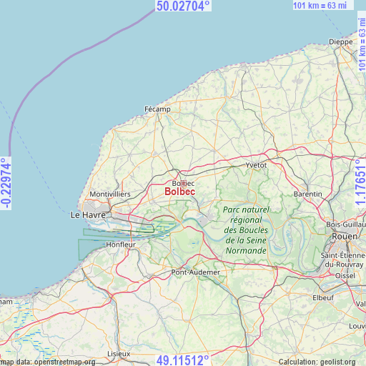
Bolbec GPS coordinates[2]
49° 34' 23.556" North, 0° 28' 24.204" East
| Map corner | latitude | longitude |
|---|---|---|
| Upper-left | 50.02704°, | -0.22974° |
| Center: | 49.57321°, | 0.47339° |
| Lower-right: | 49.11512°, | 1.17651° |
| Map W x H: | 101.4×101.4 km | = 63×63mi |
| max Lat: | 51.07786° ⇑9.8% North |
| Bolbec: | 49.57321° |
| min Lat: | ⇓90.2% South 41.3874° |
| min Long | Bolbec | max Long |
| -5.08615° | 0.47339° | 9.52242° |
| W 26.3%⇐ | ⇒73.7% E |
Elevation
Elevation of Bolbec is 54 m = 177 ft, and this is 139.7 m = 458 ft below average elevation for this country.
| Max E: |
2333 m = 7654 ft | 80.2% |
| Avg. | 193.7 m = 635 ft | |
| Bolbec | 54 m = 177 ft | |
Min E: |
-1 m = -3 ft | 19.8% |
See also: France elevation on elevation.city.
Geographical zone
Bolbec is located in North temperate zone (between Tropic of Cancer and the Arctic Circle). Distance of this North polar circle is 1889.1 km =1173.8 mi to North.| Distance of | km | miles | from Bolbec |
|---|---|---|---|
| North Pole | 4495 | 2793.1 | to North |
| Arctic Circle | 1889.1 | 1173.8 | to North |
| Tropic Cancer | 2906.1 | 1805.8 | to South |
| Equator | 5512 | 3425 | to South |


Nearby cities:
15 places around Bolbec: (largest is in red/bold)
• Bernières
5.4 km =3.4 mi,  3°
3°
• Beuzeville-la-Grenier
3.9 km =2.4 mi,  301°
301°
• Beuzevillette
4.6 km =2.9 mi,  92°
92°
• Gruchet-le-Valasse
2.3 km =1.4 mi,  154°
154°
• La Trinité-du-Mont
6.7 km =4.2 mi,  120°
120°
• Lanquetot
4 km =2.5 mi,  70°
70°
• Les Trois-Pierres
4.8 km =3 mi,  237°
237°
• Mélamare
4.2 km =2.6 mi,  198°
198°
• Nointot
2.8 km =1.7 mi, 4°
• Rouville
5.3 km =3.3 mi,  20°
20°
• Saint-Antoine-la-Forêt
4.1 km =2.5 mi,  179°
179°
• Saint-Eustache-la-Forêt
2.7 km =1.7 mi,  207°
207°
• Saint-Jean-de-Folleville
6.2 km =3.9 mi,  157°
157°
• Saint-Nicolas-de-la-Taille
6.9 km =4.3 mi, 179°
• Vattetot-sous-Beaumont
6.1 km =3.8 mi,  341°
341°
Sources, notices
• [Note1] Compared only with cities in France existing in our database
• [Src1] Map data: © OpenStreetMap contributors (CC-BY-SA)
• [Src2] Other city data from geonames.org with taken over terms of usage.
• [Src3] Geographical zone / Annual Mean Temperature by Robert A. Rohde @ Wikipedia
