Hondainville geodata
Hondainville (Hauts-de-France) is a populated place; located in France in Europe/Paris (GMT+2) time zone. With population of 649 people, there are 12531 cities with bigger population in this country. Compared to other cities in France, 86.8% of cities are located further ↓South; 52.7% of cities are located further →East and 84.1% of cities have higher elevation than Hondainville. Note1
Administrative division(s):
- Level 1: Hauts-de-France
- Level 2: Département de l'Oise
- Level 3: Arrondissement de Clermont
- Level 4: Hondainville


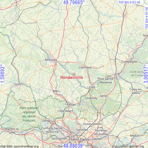
Hondainville GPS coordinates[2]
49° 20' 26.34" North, 2° 18' 7.344" East
| Map corner | latitude | longitude |
|---|---|---|
| Upper-left | 49.79665°, | 1.59892° |
| Center: | 49.34065°, | 2.30204° |
| Lower-right: | 48.88039°, | 3.00517° |
| Map W x H: | 101.9×101.9 km | = 63.3×63.3mi |
| max Lat: | 51.07786° ⇑13.2% North |
| Hondainville: | 49.34065° |
| min Lat: | ⇓86.8% South 41.3874° |
| min Long | Hondainville | max Long |
| -5.08615° | 2.30204° | 9.52242° |
| W 47.3%⇐ | ⇒52.7% E |
Elevation
Elevation of Hondainville is 44 m = 144 ft, and this is 149.7 m = 491 ft below average elevation for this country.
| Max E: |
2333 m = 7654 ft | 84.1% |
| Avg. | 193.7 m = 635 ft | |
| Hondainville | 44 m = 144 ft | |
Min E: |
-1 m = -3 ft | 15.9% |
See also: France elevation on elevation.city.
Geographical zone
Hondainville is located in North temperate zone (between Tropic of Cancer and the Arctic Circle). Distance of this North polar circle is 1915 km =1189.9 mi to North.| Distance of | km | miles | from Hondainville |
|---|---|---|---|
| North Pole | 4520.9 | 2809.2 | to North |
| Arctic Circle | 1915 | 1189.9 | to North |
| Tropic Cancer | 2880.2 | 1789.7 | to South |
| Equator | 5486.2 | 3409 | to South |


Nearby cities:
15 places around Hondainville: (largest is in red/bold)
• Angy
2.3 km =1.4 mi,  122°
122°
• Balagny-sur-Thérain
5.6 km =3.5 mi,  153°
153°
• Berthecourt
5.7 km =3.5 mi,  281°
281°
• Bury
4.3 km =2.7 mi,  135°
135°
• Cambronne-lès-Clermont
7.1 km =4.4 mi,  99°
99°
• Cauvigny
5.8 km =3.6 mi,  221°
221°
• Heilles
2.7 km =1.7 mi,  256°
256°
• Hermes
4.7 km =2.9 mi,  297°
297°
• La Neuville-en-Hez
7.2 km =4.5 mi,  13°
13°
• Mouy
3.1 km =1.9 mi,  155°
155°
• Noailles
7.5 km =4.7 mi, 259°
• Saint-Félix
2.4 km =1.5 mi,  324°
324°
• Thury-sous-Clermont
2.7 km =1.7 mi,  46°
46°
• Ully-Saint-Georges
7 km =4.3 mi,  192°
192°
• Villers-Saint-Sépulcre
6.9 km =4.3 mi,  294°
294°
Sources, notices
• [Note1] Compared only with cities in France existing in our database
• [Src1] Map data: © OpenStreetMap contributors (CC-BY-SA)
• [Src2] Other city data from geonames.org with taken over terms of usage.
• [Src3] Geographical zone / Annual Mean Temperature by Robert A. Rohde @ Wikipedia
