Lompret geodata
Lompret (Hauts-de-France) is a populated place; located in France in Europe/Paris (GMT+2) time zone. With population of 2,406 people, there are 4021 cities with bigger population in this country. Compared to other cities in France, 98.6% of cities are located further ↓South; 57.7% of cities are located further ←West and 92% of cities have higher elevation than Lompret. Note1
Administrative division(s):
- Level 1: Hauts-de-France
- Level 2: Nord
- Level 3: Arrondissement de Lille
- Level 4: Lompret


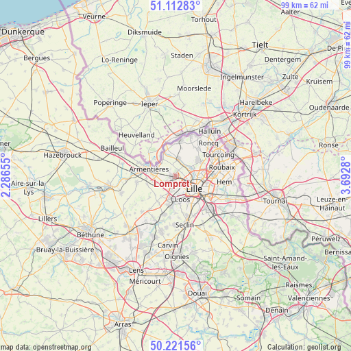
Lompret GPS coordinates[2]
50° 40' 9.516" North, 2° 59' 22.848" East
| Map corner | latitude | longitude |
|---|---|---|
| Upper-left | 51.11283°, | 2.28655° |
| Center: | 50.66931°, | 2.98968° |
| Lower-right: | 50.22156°, | 3.6928° |
| Map W x H: | 99.1×99.1 km | = 61.6×61.6mi |
| max Lat: | 51.07786° ⇑1.4% North |
| Lompret: | 50.66931° |
| min Lat: | ⇓98.6% South 41.3874° |
| min Long | Lompret | max Long |
| -5.08615° | 2.98968° | 9.52242° |
| W 57.7%⇐ | ⇒42.3% E |
Elevation
Elevation of Lompret is 25 m = 82 ft, and this is 168.7 m = 553 ft below average elevation for this country.
| Max E: |
2333 m = 7654 ft | 92% |
| Avg. | 193.7 m = 635 ft | |
| Lompret | 25 m = 82 ft | |
Min E: |
-1 m = -3 ft | 8% |
See also: France elevation on elevation.city.
Geographical zone
Lompret is located in North temperate zone (between Tropic of Cancer and the Arctic Circle). Distance of this North polar circle is 1767.3 km =1098.1 mi to North.| Distance of | km | miles | from Lompret |
|---|---|---|---|
| North Pole | 4373.2 | 2717.4 | to North |
| Arctic Circle | 1767.3 | 1098.1 | to North |
| Tropic Cancer | 3028 | 1881.5 | to South |
| Equator | 5633.9 | 3500.7 | to South |


Nearby cities:
15 places around Lompret: (largest is in red/bold)
• Capinghem
3.3 km =2.1 mi,  216°
216°
• Englos
5.3 km =3.3 mi,  205°
205°
• Ennetières-en-Weppes
5.1 km =3.2 mi, 222°
• Hallennes-lez-Haubourdin
6.1 km =3.8 mi,  195°
195°
• Houplines
6 km =3.7 mi,  298°
298°
• Lambersart
3.8 km =2.4 mi,  124°
124°
• Lomme
2.9 km =1.8 mi,  183°
183°
• Marquette-lez-Lille
5.4 km =3.4 mi,  81°
81°
• Prémesques
3.1 km =1.9 mi,  240°
240°
• Pérenchies
1.4 km =0.9 mi,  273°
273°
• Quesnoy-sur-Deûle
5 km =3.1 mi,  8°
8°
• Saint-André-lez-Lille
4.3 km =2.7 mi,  93°
93°
• Sequedin
4.9 km =3 mi,  185°
185°
• Verlinghem
1.7 km =1.1 mi,  23°
23°
• Wambrechies
4.4 km =2.7 mi,  69°
69°
Sources, notices
• [Note1] Compared only with cities in France existing in our database
• [Src1] Map data: © OpenStreetMap contributors (CC-BY-SA)
• [Src2] Other city data from geonames.org with taken over terms of usage.
• [Src3] Geographical zone / Annual Mean Temperature by Robert A. Rohde @ Wikipedia
