Prémesques geodata
Prémesques (Hauts-de-France) is a populated place; located in France in Europe/Paris (GMT+2) time zone. With population of 1,958 people, there are 4886 cities with bigger population in this country. Compared to other cities in France, 98.5% of cities are located further ↓South; 57.1% of cities are located further ←West and 88.6% of cities have higher elevation than Prémesques. Note1
Administrative division(s):
- Level 1: Hauts-de-France
- Level 2: Nord
- Level 3: Arrondissement de Lille
- Level 4: Prémesques


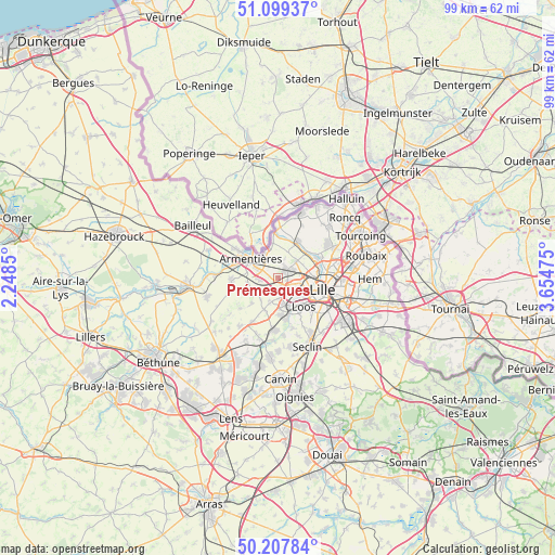
Prémesques GPS coordinates[2]
50° 39' 20.592" North, 2° 57' 5.832" East
| Map corner | latitude | longitude |
|---|---|---|
| Upper-left | 51.09937°, | 2.2485° |
| Center: | 50.65572°, | 2.95162° |
| Lower-right: | 50.20784°, | 3.65475° |
| Map W x H: | 99.1×99.1 km | = 61.6×61.6mi |
| max Lat: | 51.07786° ⇑1.5% North |
| Prémesques: | 50.65572° |
| min Lat: | ⇓98.5% South 41.3874° |
| min Long | Prémesques | max Long |
| -5.08615° | 2.95162° | 9.52242° |
| W 57.1%⇐ | ⇒42.9% E |
Elevation
Elevation of Prémesques is 33 m = 108 ft, and this is 160.7 m = 527 ft below average elevation for this country.
| Max E: |
2333 m = 7654 ft | 88.6% |
| Avg. | 193.7 m = 635 ft | |
| Prémesques | 33 m = 108 ft | |
Min E: |
-1 m = -3 ft | 11.4% |
See also: France elevation on elevation.city.
Geographical zone
Prémesques is located in North temperate zone (between Tropic of Cancer and the Arctic Circle). Distance of this North polar circle is 1768.8 km =1099.1 mi to North.| Distance of | km | miles | from Prémesques |
|---|---|---|---|
| North Pole | 4374.7 | 2718.3 | to North |
| Arctic Circle | 1768.8 | 1099.1 | to North |
| Tropic Cancer | 3026.5 | 1880.6 | to South |
| Equator | 5632.4 | 3499.8 | to South |


Nearby cities:
15 places around Prémesques: (largest is in red/bold)
• Armentières
5.9 km =3.7 mi,  304°
304°
• Bois-Grenier
5.5 km =3.4 mi,  263°
263°
• Capinghem
1.3 km =0.8 mi,  147°
147°
• Englos
3.3 km =2.1 mi,  173°
173°
• Ennetières-en-Weppes
2.4 km =1.5 mi,  199°
199°
• Hallennes-lez-Haubourdin
4.5 km =2.8 mi, 166°
• Haubourdin
6 km =3.7 mi, 151°
• Houplines
5.1 km =3.2 mi,  329°
329°
• Lambersart
5.8 km =3.6 mi,  96°
96°
• Lomme
2.8 km =1.7 mi,  118°
118°
• Lompret
3.1 km =1.9 mi,  60°
60°
• Pérenchies
2.1 km =1.3 mi,  39°
39°
• Radinghem-en-Weppes
5.1 km =3.2 mi,  216°
216°
• Sequedin
4 km =2.5 mi, 146°
• Verlinghem
4.5 km =2.8 mi,  47°
47°
Sources, notices
• [Note1] Compared only with cities in France existing in our database
• [Src1] Map data: © OpenStreetMap contributors (CC-BY-SA)
• [Src2] Other city data from geonames.org with taken over terms of usage.
• [Src3] Geographical zone / Annual Mean Temperature by Robert A. Rohde @ Wikipedia
