Capinghem geodata
Capinghem (Hauts-de-France) is a populated place; located in France in Europe/Paris (GMT+2) time zone. With population of 1,557 people, there are 5984 cities with bigger population in this country. Compared to other cities in France, 98.4% of cities are located further ↓South; 57.3% of cities are located further ←West and 83.4% of cities have higher elevation than Capinghem. Note1
Administrative division(s):
- Level 1: Hauts-de-France
- Level 2: Nord
- Level 3: Arrondissement de Lille
- Level 4: Capinghem


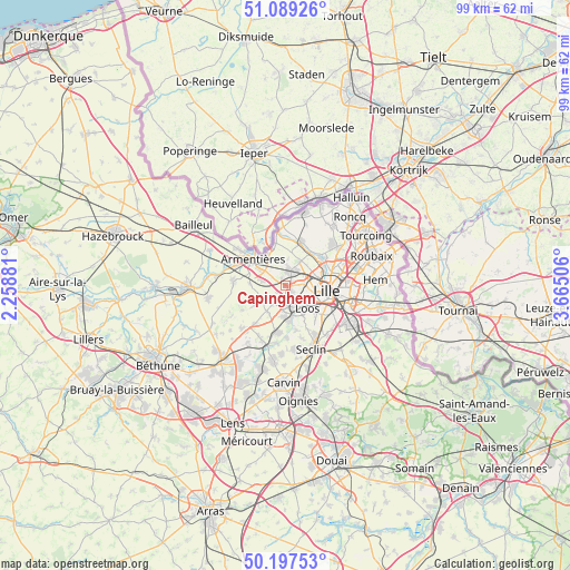
Capinghem GPS coordinates[2]
50° 38' 43.836" North, 2° 57' 42.948" East
| Map corner | latitude | longitude |
|---|---|---|
| Upper-left | 51.08926°, | 2.25881° |
| Center: | 50.64551°, | 2.96193° |
| Lower-right: | 50.19753°, | 3.66506° |
| Map W x H: | 99.2×99.1 km | = 61.6×61.6mi |
| max Lat: | 51.07786° ⇑1.6% North |
| Capinghem: | 50.64551° |
| min Lat: | ⇓98.4% South 41.3874° |
| min Long | Capinghem | max Long |
| -5.08615° | 2.96193° | 9.52242° |
| W 57.3%⇐ | ⇒42.7% E |
Elevation
Elevation of Capinghem is 46 m = 151 ft, and this is 147.7 m = 485 ft below average elevation for this country.
| Max E: |
2333 m = 7654 ft | 83.4% |
| Avg. | 193.7 m = 635 ft | |
| Capinghem | 46 m = 151 ft | |
Min E: |
-1 m = -3 ft | 16.6% |
See also: France elevation on elevation.city.
Geographical zone
Capinghem is located in North temperate zone (between Tropic of Cancer and the Arctic Circle). Distance of this North polar circle is 1769.9 km =1099.8 mi to North.| Distance of | km | miles | from Capinghem |
|---|---|---|---|
| North Pole | 4375.8 | 2719 | to North |
| Arctic Circle | 1769.9 | 1099.8 | to North |
| Tropic Cancer | 3025.3 | 1879.8 | to South |
| Equator | 5631.3 | 3499.1 | to South |


Nearby cities:
15 places around Capinghem: (largest is in red/bold)
• Beaucamps-Ligny
5.5 km =3.4 mi,  216°
216°
• Englos
2.1 km =1.3 mi,  189°
189°
• Ennetières-en-Weppes
1.9 km =1.2 mi,  233°
233°
• Hallennes-lez-Haubourdin
3.2 km =2 mi,  174°
174°
• Haubourdin
4.6 km =2.9 mi,  153°
153°
• Lambersart
5.1 km =3.2 mi,  84°
84°
• Lomme
1.8 km =1.1 mi,  96°
96°
• Lompret
3.3 km =2.1 mi,  36°
36°
• Loos
5.6 km =3.5 mi,  134°
134°
• Prémesques
1.3 km =0.8 mi,  327°
327°
• Pérenchies
2.8 km =1.7 mi,  12°
12°
• Radinghem-en-Weppes
4.8 km =3 mi, 231°
• Santes
5.8 km =3.6 mi,  179°
179°
• Sequedin
2.6 km =1.6 mi, 146°
• Verlinghem
4.9 km =3 mi,  32°
32°
Sources, notices
• [Note1] Compared only with cities in France existing in our database
• [Src1] Map data: © OpenStreetMap contributors (CC-BY-SA)
• [Src2] Other city data from geonames.org with taken over terms of usage.
• [Src3] Geographical zone / Annual Mean Temperature by Robert A. Rohde @ Wikipedia
