Laurens geodata
Laurens (Occitanie) is a populated place; located in France in Europe/Paris (GMT+2) time zone. With population of 1,048 people, there are 8479 cities with bigger population in this country. Compared to other cities in France, 92.8% of cities are located further ↑North; 60.6% of cities are located further ←West and 53.9% of cities have lower elevation than Laurens. Note1
Administrative division(s):
- Level 1: Occitanie
- Level 2: Département de l'Hérault
- Level 3: Arrondissement de Béziers
- Level 4: Laurens


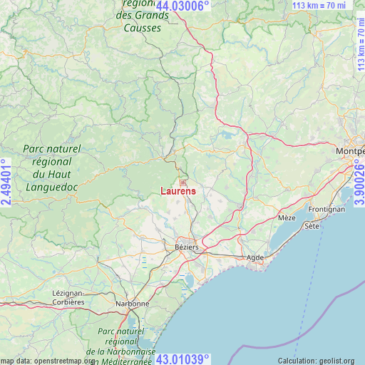
Laurens GPS coordinates[2]
43° 31' 20.568" North, 3° 11' 49.704" East
| Map corner | latitude | longitude |
|---|---|---|
| Upper-left | 44.03006°, | 2.49401° |
| Center: | 43.52238°, | 3.19714° |
| Lower-right: | 43.01039°, | 3.90026° |
| Map W x H: | 113.4×113.4 km | = 70.5×70.5mi |
| max Lat: | 51.07786° ⇑92.8% North |
| Laurens: | 43.52238° |
| min Lat: | ⇓7.2% South 41.3874° |
| min Long | Laurens | max Long |
| -5.08615° | 3.19714° | 9.52242° |
| W 60.6%⇐ | ⇒39.4% E |
Elevation
Elevation of Laurens is 146 m = 479 ft, and this is 47.7 m = 156 ft below average elevation for this country.
| Max E: |
2333 m = 7654 ft | 46.1% |
| Avg. | 193.7 m = 635 ft | |
| Laurens | 146 m = 479 ft | |
Min E: |
-1 m = -3 ft | 53.9% |
See also: France elevation on elevation.city.
Geographical zone
Laurens is located in North temperate zone (between Tropic of Cancer and the Arctic Circle). Distance of this Northern Tropic circle is 2233.3 km =1387.7 mi to South.| Distance of | km | miles | from Laurens |
|---|---|---|---|
| North Pole | 5167.8 | 3211.1 | to North |
| Arctic Circle | 2561.9 | 1591.9 | to North |
| Tropic Cancer | 2233.3 | 1387.7 | to South |
| Equator | 4839.2 | 3006.9 | to South |


Nearby cities:
15 places around Laurens: (largest is in red/bold)
• Autignac
3.4 km =2.1 mi,  220°
220°
• Bédarieux
10.8 km =6.7 mi,  342°
342°
• Causses-et-Veyran
10.4 km =6.5 mi,  239°
239°
• Espondeilhan
10.5 km =6.5 mi,  149°
149°
• Gabian
6.2 km =3.9 mi,  99°
99°
• Hérépian
10.2 km =6.3 mi,  320°
320°
• Les Aires
10 km =6.2 mi,  311°
311°
• Magalas
6.1 km =3.8 mi,  159°
159°
• Neffiès
11 km =6.8 mi,  83°
83°
• Pailhès
10.2 km =6.3 mi,  185°
185°
• Pouzolles
7.9 km =4.9 mi,  123°
123°
• Puimisson
9.4 km =5.8 mi,  175°
175°
• Puissalicon
7.8 km =4.8 mi, 155°
• Roujan
9.4 km =5.8 mi, 101°
• Saint-Geniès-de-Fontedit
6.3 km =3.9 mi, 190°
Sources, notices
• [Note1] Compared only with cities in France existing in our database
• [Src1] Map data: © OpenStreetMap contributors (CC-BY-SA)
• [Src2] Other city data from geonames.org with taken over terms of usage.
• [Src3] Geographical zone / Annual Mean Temperature by Robert A. Rohde @ Wikipedia
