La Londe-les-Maures geodata
La Londe-les-Maures (Provence-Alpes-Côte d'Azur) is a populated place; located in France in Europe/Paris (GMT+2) time zone. With population of 9,471 people, there are 1011 cities with bigger population in this country. Compared to other cities in France, 97.7% of cities are located further ↑North; 89.6% of cities are located further ←West and 93.9% of cities have higher elevation than La Londe-les-Maures. Note1
Administrative division(s):
- Level 1: Provence-Alpes-Côte d'Azur
- Level 2: Var
- Level 3: Arrondissement de Toulon
- Level 4: La Londe-les-Maures


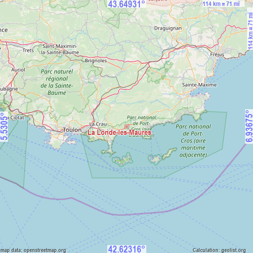
La Londe-les-Maures GPS coordinates[2]
43° 8' 18.204" North, 6° 14' 1.032" East
| Map corner | latitude | longitude |
|---|---|---|
| Upper-left | 43.64931°, | 5.5305° |
| Center: | 43.13839°, | 6.23362° |
| Lower-right: | 42.62316°, | 6.93675° |
| Map W x H: | 114.1×114.1 km | = 70.9×70.9mi |
| max Lat: | 51.07786° ⇑97.7% North |
| La Londe-les-Maures: | 43.13839° |
| min Lat: | ⇓2.3% South 41.3874° |
| min Long | La Londe-les-Ma | max Long |
| -5.08615° | 6.23362° | 9.52242° |
| W 89.6%⇐ | ⇒10.4% E |
Elevation
Elevation of La Londe-les-Maures is 20 m = 66 ft, and this is 173.7 m = 570 ft below average elevation for this country.
| Max E: |
2333 m = 7654 ft | 93.9% |
| Avg. | 193.7 m = 635 ft | |
| La Londe-les-Maures | 20 m = 66 ft | |
Min E: |
-1 m = -3 ft | 6.1% |
See also: France elevation on elevation.city.
Geographical zone
La Londe-les-Maures is located in North temperate zone (between Tropic of Cancer and the Arctic Circle). Distance of this Northern Tropic circle is 2190.6 km =1361.2 mi to South.| Distance of | km | miles | from La Londe-les-Maures |
|---|---|---|---|
| North Pole | 5210.5 | 3237.7 | to North |
| Arctic Circle | 2604.6 | 1618.4 | to North |
| Tropic Cancer | 2190.6 | 1361.2 | to South |
| Equator | 4796.5 | 2980.4 | to South |


Nearby cities:
15 places around La Londe-les-Maures: (largest is in red/bold)
• Bormes-les-Mimosas
8.9 km =5.5 mi,  80°
80°
• Carqueiranne
13.9 km =8.6 mi,  249°
249°
• Collobrières
12.6 km =7.8 mi,  29°
29°
• Cuers
17.1 km =10.6 mi,  310°
310°
• Hyères
8.8 km =5.5 mi,  256°
256°
• La Crau
13 km =8.1 mi,  275°
275°
• La Farlède
15.8 km =9.8 mi, 282°
• La Garde
18.2 km =11.3 mi,  265°
265°
• Le Lavandou
10.7 km =6.6 mi,  90°
90°
• Le Pradet
17.4 km =10.8 mi, 257°
• Pierrefeu-du-Var
11.9 km =7.4 mi,  323°
323°
• Pignans
18.1 km =11.2 mi,  358°
358°
• Solliès-Pont
16.6 km =10.3 mi,  290°
290°
• Solliès-Toucas
18.5 km =11.5 mi, 293°
• Solliès-Ville
16.6 km =10.3 mi, 287°
Sources, notices
• [Note1] Compared only with cities in France existing in our database
• [Src1] Map data: © OpenStreetMap contributors (CC-BY-SA)
• [Src2] Other city data from geonames.org with taken over terms of usage.
• [Src3] Geographical zone / Annual Mean Temperature by Robert A. Rohde @ Wikipedia
