Hyères geodata
Hyères (Provence-Alpes-Côte d'Azur) is a populated place; located in France in Europe/Paris (GMT+2) time zone. With population of 50,487 people, there are 125 cities with bigger population in this country. Compared to other cities in France, 97.8% of cities are located further ↑North; 88.6% of cities are located further ←West and 85.3% of cities have higher elevation than Hyères. Note1
Administrative division(s):
- Level 1: Provence-Alpes-Côte d'Azur
- Level 2: Var
- Level 3: Arrondissement de Toulon
- Level 4: Hyères


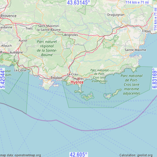
Hyères GPS coordinates[2]
43° 7' 13.368" North, 6° 7' 42.852" East
| Map corner | latitude | longitude |
|---|---|---|
| Upper-left | 43.63145°, | 5.42544° |
| Center: | 43.12038°, | 6.12857° |
| Lower-right: | 42.605°, | 6.83169° |
| Map W x H: | 114.1×114.1 km | = 70.9×70.9mi |
| max Lat: | 51.07786° ⇑97.8% North |
| Hyères: | 43.12038° |
| min Lat: | ⇓2.2% South 41.3874° |
| min Long | Hyères | max Long |
| -5.08615° | 6.12857° | 9.52242° |
| W 88.6%⇐ | ⇒11.4% E |
Elevation
Elevation of Hyères is 41 m = 135 ft, and this is 152.7 m = 501 ft below average elevation for this country.
| Max E: |
2333 m = 7654 ft | 85.3% |
| Avg. | 193.7 m = 635 ft | |
| Hyères | 41 m = 135 ft | |
Min E: |
-1 m = -3 ft | 14.7% |
See also: Hyères elevation on elevation.city.
Geographical zone
Hyères is located in North temperate zone (between Tropic of Cancer and the Arctic Circle). Distance of this Northern Tropic circle is 2188.6 km =1359.9 mi to South.| Distance of | km | miles | from Hyères |
|---|---|---|---|
| North Pole | 5212.5 | 3238.9 | to North |
| Arctic Circle | 2606.6 | 1619.7 | to North |
| Tropic Cancer | 2188.6 | 1359.9 | to South |
| Equator | 4794.5 | 2979.2 | to South |


Nearby cities:
15 places around Hyères: (largest is in red/bold)
• Belgentier
17.4 km =10.8 mi,  322°
322°
• Carqueiranne
5.3 km =3.3 mi,  237°
237°
• Cuers
13.8 km =8.6 mi,  340°
340°
• La Crau
5.5 km =3.4 mi,  306°
306°
• La Farlède
8.8 km =5.5 mi, 307°
• La Garde
9.6 km =6 mi,  272°
272°
• La Londe-les-Maures
8.8 km =5.5 mi,  76°
76°
• La Valette-du-Var
12 km =7.5 mi,  279°
279°
• Le Pradet
8.7 km =5.4 mi,  258°
258°
• Pierrefeu-du-Var
11.6 km =7.2 mi,  6°
6°
• Saint-Mandrier-sur-Mer
16.9 km =10.5 mi,  253°
253°
• Solliès-Pont
10.5 km =6.5 mi, 317°
• Solliès-Toucas
12.7 km =7.9 mi, 318°
• Solliès-Ville
10.1 km =6.3 mi, 313°
• Toulon
16.3 km =10.1 mi, 271°
Sources, notices
• [Note1] Compared only with cities in France existing in our database
• [Src1] Map data: © OpenStreetMap contributors (CC-BY-SA)
• [Src2] Other city data from geonames.org with taken over terms of usage.
• [Src3] Geographical zone / Annual Mean Temperature by Robert A. Rohde @ Wikipedia
