Solliès-Pont geodata
Solliès-Pont (Provence-Alpes-Côte d'Azur) is a populated place; located in France in Europe/Paris (GMT+2) time zone. With population of 12,052 people, there are 797 cities with bigger population in this country. Compared to other cities in France, 97.2% of cities are located further ↑North; 87.5% of cities are located further ←West and 71.9% of cities have higher elevation than Solliès-Pont. Note1
Administrative division(s):
- Level 1: Provence-Alpes-Côte d'Azur
- Level 2: Var
- Level 3: Arrondissement de Toulon
- Level 4: Solliès-Pont


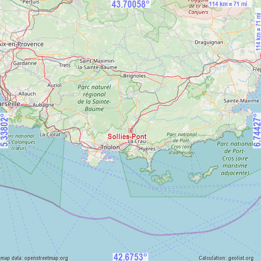
Solliès-Pont GPS coordinates[2]
43° 11' 24.324" North, 6° 2' 28.14" East
| Map corner | latitude | longitude |
|---|---|---|
| Upper-left | 43.70058°, | 5.33802° |
| Center: | 43.19009°, | 6.04115° |
| Lower-right: | 42.6753°, | 6.74427° |
| Map W x H: | 114×114 km | = 70.8×70.8mi |
| max Lat: | 51.07786° ⇑97.2% North |
| Solliès-Pont: | 43.19009° |
| min Lat: | ⇓2.8% South 41.3874° |
| min Long | Solliès-Pont | max Long |
| -5.08615° | 6.04115° | 9.52242° |
| W 87.5%⇐ | ⇒12.5% E |
Elevation
Elevation of Solliès-Pont is 74 m = 243 ft, and this is 119.7 m = 393 ft below average elevation for this country.
| Max E: |
2333 m = 7654 ft | 71.9% |
| Avg. | 193.7 m = 635 ft | |
| Solliès-Pont | 74 m = 243 ft | |
Min E: |
-1 m = -3 ft | 28.1% |
See also: France elevation on elevation.city.
Geographical zone
Solliès-Pont is located in North temperate zone (between Tropic of Cancer and the Arctic Circle). Distance of this Northern Tropic circle is 2196.4 km =1364.8 mi to South.| Distance of | km | miles | from Solliès-Pont |
|---|---|---|---|
| North Pole | 5204.8 | 3234.1 | to North |
| Arctic Circle | 2598.9 | 1614.9 | to North |
| Tropic Cancer | 2196.4 | 1364.8 | to South |
| Equator | 4802.3 | 2984 | to South |


Nearby cities:
15 places around Solliès-Pont: (largest is in red/bold)
• Belgentier
7 km =4.3 mi,  331°
331°
• Carqueiranne
10.9 km =6.8 mi,  166°
166°
• Cuers
5.8 km =3.6 mi,  25°
25°
• Hyères
10.5 km =6.5 mi,  137°
137°
• La Crau
5.2 km =3.2 mi,  149°
149°
• La Farlède
2.4 km =1.5 mi,  175°
175°
• La Garde
7.7 km =4.8 mi,  198°
198°
• La Valette-du-Var
7.5 km =4.7 mi,  218°
218°
• Le Pradet
9.5 km =5.9 mi,  188°
188°
• Le Revest-les-Eaux
9.4 km =5.8 mi,  260°
260°
• Méounes-lès-Montrieux
11.6 km =7.2 mi, 330°
• Pierrefeu-du-Var
9.3 km =5.8 mi,  65°
65°
• Solliès-Toucas
2.2 km =1.4 mi,  322°
322°
• Solliès-Ville
0.9 km =0.6 mi, 194°
• Toulon
11.7 km =7.3 mi,  231°
231°
Sources, notices
• [Note1] Compared only with cities in France existing in our database
• [Src1] Map data: © OpenStreetMap contributors (CC-BY-SA)
• [Src2] Other city data from geonames.org with taken over terms of usage.
• [Src3] Geographical zone / Annual Mean Temperature by Robert A. Rohde @ Wikipedia
