Collobrières geodata
Collobrières (Provence-Alpes-Côte d'Azur) is a populated place; located in France in Europe/Paris (GMT+2) time zone. With population of 1,651 people, there are 5661 cities with bigger population in this country. Compared to other cities in France, 96.7% of cities are located further ↑North; 90.3% of cities are located further ←West and 57.1% of cities have lower elevation than Collobrières. Note1
Administrative division(s):
- Level 1: Provence-Alpes-Côte d'Azur
- Level 2: Var
- Level 3: Arrondissement de Toulon
- Level 4: Collobrières


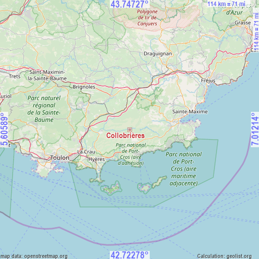
Collobrières GPS coordinates[2]
43° 14' 13.848" North, 6° 18' 32.436" East
| Map corner | latitude | longitude |
|---|---|---|
| Upper-left | 43.74727°, | 5.60589° |
| Center: | 43.23718°, | 6.30901° |
| Lower-right: | 42.72278°, | 7.01214° |
| Map W x H: | 113.9×113.9 km | = 70.8×70.8mi |
| max Lat: | 51.07786° ⇑96.7% North |
| Collobrières: | 43.23718° |
| min Lat: | ⇓3.3% South 41.3874° |
| min Long | Collobrières | max Long |
| -5.08615° | 6.30901° | 9.52242° |
| W 90.3%⇐ | ⇒9.7% E |
Elevation
Elevation of Collobrières is 158 m = 518 ft, and this is 35.7 m = 117 ft below average elevation for this country.
| Max E: |
2333 m = 7654 ft | 42.9% |
| Avg. | 193.7 m = 635 ft | |
| Collobrières | 158 m = 518 ft | |
Min E: |
-1 m = -3 ft | 57.1% |
See also: France elevation on elevation.city.
Geographical zone
Collobrières is located in North temperate zone (between Tropic of Cancer and the Arctic Circle). Distance of this Northern Tropic circle is 2201.6 km =1368 mi to South.| Distance of | km | miles | from Collobrières |
|---|---|---|---|
| North Pole | 5199.5 | 3230.8 | to North |
| Arctic Circle | 2593.7 | 1611.6 | to North |
| Tropic Cancer | 2201.6 | 1368 | to South |
| Equator | 4807.5 | 2987.2 | to South |


Nearby cities:
15 places around Collobrières: (largest is in red/bold)
• Besse-sur-Issole
16.4 km =10.2 mi,  319°
319°
• Bormes-les-Mimosas
9.9 km =6.2 mi,  164°
164°
• Carnoules
12.2 km =7.6 mi,  306°
306°
• Flassans-sur-Issole
16.2 km =10.1 mi,  334°
334°
• Gonfaron
9.4 km =5.8 mi,  350°
350°
• La Garde-Freinet
15.7 km =9.8 mi,  55°
55°
• La Londe-les-Maures
12.6 km =7.8 mi,  209°
209°
• La Môle
13.2 km =8.2 mi,  104°
104°
• Le Cannet-des-Maures
17.4 km =10.8 mi,  8°
8°
• Le Lavandou
12.1 km =7.5 mi, 157°
• Le Luc
17.5 km =10.9 mi,  0°
0°
• Les Mayons
9.3 km =5.8 mi,  25°
25°
• Pierrefeu-du-Var
13.3 km =8.3 mi,  263°
263°
• Pignans
9.7 km =6 mi, 316°
• Puget-Ville
15.2 km =9.4 mi,  292°
292°
Sources, notices
• [Note1] Compared only with cities in France existing in our database
• [Src1] Map data: © OpenStreetMap contributors (CC-BY-SA)
• [Src2] Other city data from geonames.org with taken over terms of usage.
• [Src3] Geographical zone / Annual Mean Temperature by Robert A. Rohde @ Wikipedia
