Lagrave geodata
Lagrave (Occitanie) is a populated place; located in France in Europe/Paris (GMT+2) time zone. With population of 1,315 people, there are 6956 cities with bigger population in this country. Compared to other cities in France, 88.1% of cities are located further ↑North; 57.2% of cities are located further →East and 56.8% of cities have lower elevation than Lagrave. Note1


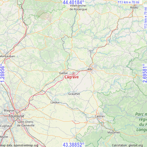
Lagrave GPS coordinates[2]
43° 53' 50.424" North, 1° 59' 33.648" East
| Map corner | latitude | longitude |
|---|---|---|
| Upper-left | 44.40184°, | 1.28956° |
| Center: | 43.89734°, | 1.99268° |
| Lower-right: | 43.38852°, | 2.69581° |
| Map W x H: | 112.7×112.7 km | = 70×70mi |
| max Lat: | 51.07786° ⇑88.1% North |
| Lagrave: | 43.89734° |
| min Lat: | ⇓11.9% South 41.3874° |
| min Long | Lagrave | max Long |
| -5.08615° | 1.99268° | 9.52242° |
| W 42.8%⇐ | ⇒57.2% E |
Elevation
Elevation of Lagrave is 157 m = 515 ft, and this is 36.7 m = 120 ft below average elevation for this country.
| Max E: |
2333 m = 7654 ft | 43.2% |
| Avg. | 193.7 m = 635 ft | |
| Lagrave | 157 m = 515 ft | |
Min E: |
-1 m = -3 ft | 56.8% |
See also: France elevation on elevation.city.
Geographical zone
Lagrave is located in North temperate zone (between Tropic of Cancer and the Arctic Circle). Distance of this Northern Tropic circle is 2275 km =1413.6 mi to South.| Distance of | km | miles | from Lagrave |
|---|---|---|---|
| North Pole | 5126.1 | 3185.2 | to North |
| Arctic Circle | 2520.2 | 1566 | to North |
| Tropic Cancer | 2275 | 1413.6 | to South |
| Equator | 4880.9 | 3032.8 | to South |


Nearby cities:
15 places around Lagrave: (largest is in red/bold)
• Brens
6.9 km =4.3 mi,  260°
260°
• Cadalen
5.4 km =3.4 mi,  190°
190°
• Carlus
9.4 km =5.8 mi,  96°
96°
• Castelnau-de-Lévis
8.8 km =5.5 mi,  57°
57°
• Florentin
3.4 km =2.1 mi,  107°
107°
• Gaillac
7.7 km =4.8 mi,  273°
273°
• Labastide-de-Lévis
3.6 km =2.2 mi,  21°
21°
• Le Sequestre
10.2 km =6.3 mi,  81°
81°
• Marssac-sur-Tarn
3.7 km =2.3 mi,  52°
52°
• Montans
9.2 km =5.7 mi,  248°
248°
• Rivières
3 km =1.9 mi,  307°
307°
• Rouffiac
6.3 km =3.9 mi, 104°
• Senouillac
6.1 km =3.8 mi,  324°
324°
• Terssac
7.2 km =4.5 mi, 62°
• Técou
6.9 km =4.3 mi,  209°
209°
Sources, notices
• [Note1] Compared only with cities in France existing in our database
• [Src1] Map data: © OpenStreetMap contributors (CC-BY-SA)
• [Src2] Other city data from geonames.org with taken over terms of usage.
• [Src3] Geographical zone / Annual Mean Temperature by Robert A. Rohde @ Wikipedia
