Cadalen geodata
Cadalen (Occitanie) is a populated place; located in France in Europe/Paris (GMT+2) time zone. With population of 1,266 people, there are 7204 cities with bigger population in this country. Compared to other cities in France, 88.6% of cities are located further ↑North; 57.4% of cities are located further →East and 67.8% of cities have lower elevation than Cadalen. Note1


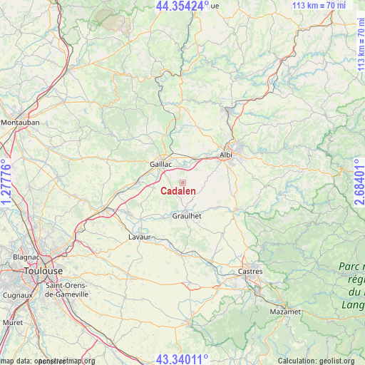
Cadalen GPS coordinates[2]
43° 50' 57.588" North, 1° 58' 51.204" East
| Map corner | latitude | longitude |
|---|---|---|
| Upper-left | 44.35424°, | 1.27776° |
| Center: | 43.84933°, | 1.98089° |
| Lower-right: | 43.34011°, | 2.68401° |
| Map W x H: | 112.8×112.8 km | = 70.1×70.1mi |
| max Lat: | 51.07786° ⇑88.6% North |
| Cadalen: | 43.84933° |
| min Lat: | ⇓11.4% South 41.3874° |
| min Long | Cadalen | max Long |
| -5.08615° | 1.98089° | 9.52242° |
| W 42.6%⇐ | ⇒57.4% E |
Elevation
Elevation of Cadalen is 208 m = 682 ft, and this is 14.3 m = 47 ft above average elevation for this country.
| Max E: |
2333 m = 7654 ft | 32.2% |
| Cadalen | 208 m 682 ft | |
| Avg. | 193.7 m = 635 ft | |
Min E: |
-1 m = -3 ft | 67.8% |
See also: France elevation on elevation.city.
Geographical zone
Cadalen is located in North temperate zone (between Tropic of Cancer and the Arctic Circle). Distance of this Northern Tropic circle is 2269.7 km =1410.3 mi to South.| Distance of | km | miles | from Cadalen |
|---|---|---|---|
| North Pole | 5131.5 | 3188.6 | to North |
| Arctic Circle | 2525.6 | 1569.3 | to North |
| Tropic Cancer | 2269.7 | 1410.3 | to South |
| Equator | 4875.6 | 3029.6 | to South |


Nearby cities:
15 places around Cadalen: (largest is in red/bold)
• Brens
7.3 km =4.5 mi,  305°
305°
• Busque
7.7 km =4.8 mi,  192°
192°
• Carlus
11.1 km =6.9 mi,  67°
67°
• Florentin
6 km =3.7 mi,  44°
44°
• Gaillac
8.9 km =5.5 mi, 310°
• Graulhet
9.2 km =5.7 mi,  175°
175°
• Labastide-de-Lévis
9 km =5.6 mi,  14°
14°
• Labessière-Candeil
5.6 km =3.5 mi,  159°
159°
• Lagrave
5.4 km =3.4 mi, 10°
• Marssac-sur-Tarn
8.5 km =5.3 mi,  27°
27°
• Montans
7.9 km =4.9 mi,  284°
284°
• Rivières
7.3 km =4.5 mi,  348°
348°
• Rouffiac
8 km =5 mi,  61°
61°
• Senouillac
10.7 km =6.6 mi, 345°
• Técou
2.6 km =1.6 mi,  255°
255°
Sources, notices
• [Note1] Compared only with cities in France existing in our database
• [Src1] Map data: © OpenStreetMap contributors (CC-BY-SA)
• [Src2] Other city data from geonames.org with taken over terms of usage.
• [Src3] Geographical zone / Annual Mean Temperature by Robert A. Rohde @ Wikipedia
