Técou geodata
Técou (Occitanie) is a populated place; located in France in Europe/Paris (GMT+2) time zone. With population of 666 people, there are 12279 cities with bigger population in this country. Compared to other cities in France, 88.7% of cities are located further ↑North; 57.7% of cities are located further →East and 75.8% of cities have lower elevation than Técou. Note1


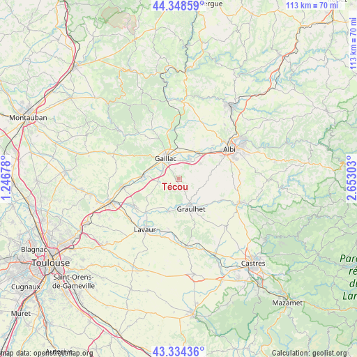
Técou GPS coordinates[2]
43° 50' 37.068" North, 1° 56' 59.64" East
| Map corner | latitude | longitude |
|---|---|---|
| Upper-left | 44.34859°, | 1.24678° |
| Center: | 43.84363°, | 1.9499° |
| Lower-right: | 43.33436°, | 2.65303° |
| Map W x H: | 112.8×112.8 km | = 70.1×70.1mi |
| max Lat: | 51.07786° ⇑88.7% North |
| Técou: | 43.84363° |
| min Lat: | ⇓11.3% South 41.3874° |
| min Long | Técou | max Long |
| -5.08615° | 1.9499° | 9.52242° |
| W 42.3%⇐ | ⇒57.7% E |
Elevation
Elevation of Técou is 255 m = 837 ft, and this is 61.3 m = 201 ft above average elevation for this country.
| Max E: |
2333 m = 7654 ft | 24.2% |
| Técou | 255 m 837 ft | |
| Avg. | 193.7 m = 635 ft | |
Min E: |
-1 m = -3 ft | 75.8% |
See also: France elevation on elevation.city.
Geographical zone
Técou is located in North temperate zone (between Tropic of Cancer and the Arctic Circle). Distance of this Northern Tropic circle is 2269 km =1409.9 mi to South.| Distance of | km | miles | from Técou |
|---|---|---|---|
| North Pole | 5132.1 | 3188.9 | to North |
| Arctic Circle | 2526.2 | 1569.7 | to North |
| Tropic Cancer | 2269 | 1409.9 | to South |
| Equator | 4875 | 3029.2 | to South |


Nearby cities:
15 places around Técou: (largest is in red/bold)
• Brens
5.9 km =3.7 mi,  324°
324°
• Briatexte
10.7 km =6.6 mi,  198°
198°
• Busque
6.9 km =4.3 mi,  173°
173°
• Cadalen
2.6 km =1.6 mi,  75°
75°
• Florentin
8.3 km =5.2 mi,  53°
53°
• Gaillac
7.7 km =4.8 mi,  326°
326°
• Graulhet
9.1 km =5.7 mi,  159°
159°
• Labastide-de-Lévis
10.5 km =6.5 mi,  27°
27°
• Labessière-Candeil
6.4 km =4 mi,  135°
135°
• Lagrave
6.9 km =4.3 mi, 29°
• Marssac-sur-Tarn
10.4 km =6.5 mi,  37°
37°
• Montans
5.8 km =3.6 mi,  296°
296°
• Parisot
10.9 km =6.8 mi,  243°
243°
• Rivières
7.9 km =4.9 mi,  7°
7°
• Rouffiac
10.5 km =6.5 mi,  65°
65°
Sources, notices
• [Note1] Compared only with cities in France existing in our database
• [Src1] Map data: © OpenStreetMap contributors (CC-BY-SA)
• [Src2] Other city data from geonames.org with taken over terms of usage.
• [Src3] Geographical zone / Annual Mean Temperature by Robert A. Rohde @ Wikipedia
