Marssac-sur-Tarn geodata
Marssac-sur-Tarn (Occitanie) is a populated place; located in France in Europe/Paris (GMT+2) time zone. With population of 2,531 people, there are 3851 cities with bigger population in this country. Compared to other cities in France, 87.9% of cities are located further ↑North; 56.8% of cities are located further →East and 55.3% of cities have lower elevation than Marssac-sur-Tarn. Note1
Administrative division(s):
- Level 1: Occitanie
- Level 2: Tarn
- Level 3: Albi
- Level 4: Marssac-sur-Tarn


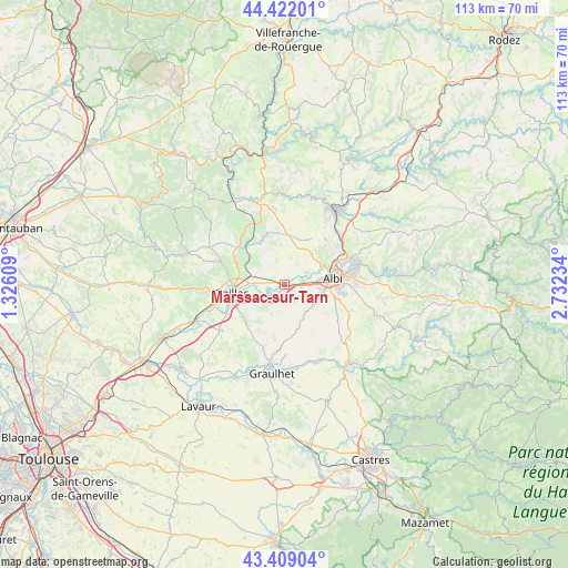
Marssac-sur-Tarn GPS coordinates[2]
43° 55' 3.648" North, 2° 1' 45.156" East
| Map corner | latitude | longitude |
|---|---|---|
| Upper-left | 44.42201°, | 1.32609° |
| Center: | 43.91768°, | 2.02921° |
| Lower-right: | 43.40904°, | 2.73234° |
| Map W x H: | 112.6×112.6 km | = 70×70mi |
| max Lat: | 51.07786° ⇑87.9% North |
| Marssac-sur-Tarn: | 43.91768° |
| min Lat: | ⇓12.1% South 41.3874° |
| min Long | Marssac-sur-Tar | max Long |
| -5.08615° | 2.02921° | 9.52242° |
| W 43.2%⇐ | ⇒56.8% E |
Elevation
Elevation of Marssac-sur-Tarn is 151 m = 495 ft, and this is 42.7 m = 140 ft below average elevation for this country.
| Max E: |
2333 m = 7654 ft | 44.7% |
| Avg. | 193.7 m = 635 ft | |
| Marssac-sur-Tarn | 151 m = 495 ft | |
Min E: |
-1 m = -3 ft | 55.3% |
See also: France elevation on elevation.city.
Geographical zone
Marssac-sur-Tarn is located in North temperate zone (between Tropic of Cancer and the Arctic Circle). Distance of this Northern Tropic circle is 2277.3 km =1415 mi to South.| Distance of | km | miles | from Marssac-sur-Tarn |
|---|---|---|---|
| North Pole | 5123.9 | 3183.8 | to North |
| Arctic Circle | 2518 | 1564.6 | to North |
| Tropic Cancer | 2277.3 | 1415 | to South |
| Equator | 4883.2 | 3034.3 | to South |


Nearby cities:
15 places around Marssac-sur-Tarn: (largest is in red/bold)
• Albi
9.6 km =6 mi,  81°
81°
• Brens
10.3 km =6.4 mi,  250°
250°
• Cadalen
8.5 km =5.3 mi,  207°
207°
• Carlus
7.2 km =4.5 mi,  117°
117°
• Castelnau-de-Lévis
5.1 km =3.2 mi,  61°
61°
• Florentin
3.3 km =2.1 mi,  174°
174°
• Labastide-de-Lévis
1.9 km =1.2 mi,  305°
305°
• Lagrave
3.7 km =2.3 mi,  232°
232°
• Le Sequestre
7.2 km =4.5 mi,  96°
96°
• Rivières
5.3 km =3.3 mi,  265°
265°
• Rouffiac
5 km =3.1 mi,  140°
140°
• Saliès
8.5 km =5.3 mi,  109°
109°
• Senouillac
7 km =4.3 mi,  292°
292°
• Terssac
3.6 km =2.2 mi,  72°
72°
• Técou
10.4 km =6.5 mi,  217°
217°
Sources, notices
• [Note1] Compared only with cities in France existing in our database
• [Src1] Map data: © OpenStreetMap contributors (CC-BY-SA)
• [Src2] Other city data from geonames.org with taken over terms of usage.
• [Src3] Geographical zone / Annual Mean Temperature by Robert A. Rohde @ Wikipedia
