La Frette-sur-Seine geodata
La Frette-sur-Seine (Île-de-France) is a populated place; located in France in Europe/Paris (GMT+2) time zone. With population of 4,649 people, there are 2130 cities with bigger population in this country. Compared to other cities in France, 79.2% of cities are located further ↓South; 54.7% of cities are located further →East and 79.4% of cities have higher elevation than La Frette-sur-Seine. Note1
Administrative division(s):
- Level 1: Île-de-France
- Level 2: Département du Val-d’Oise
- Level 3: Arrondissement d'Argenteuil
- Level 4: La Frette-sur-Seine


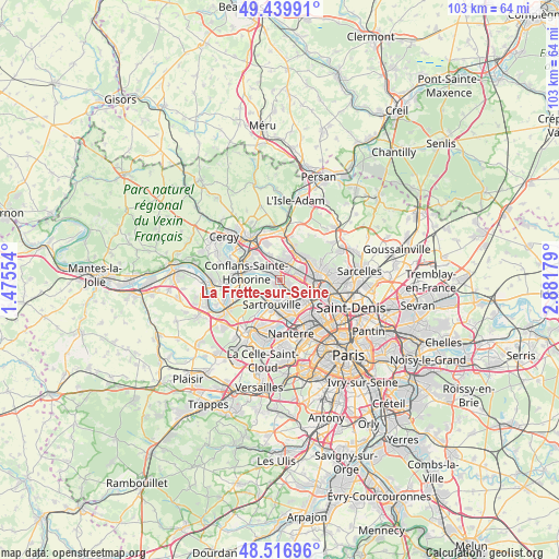
La Frette-sur-Seine GPS coordinates[2]
48° 58' 50.052" North, 2° 10' 43.176" East
| Map corner | latitude | longitude |
|---|---|---|
| Upper-left | 49.43991°, | 1.47554° |
| Center: | 48.98057°, | 2.17866° |
| Lower-right: | 48.51696°, | 2.88179° |
| Map W x H: | 102.6×102.6 km | = 63.8×63.8mi |
| max Lat: | 51.07786° ⇑20.8% North |
| La Frette-sur-Seine: | 48.98057° |
| min Lat: | ⇓79.2% South 41.3874° |
| min Long | La Frette-sur-S | max Long |
| -5.08615° | 2.17866° | 9.52242° |
| W 45.3%⇐ | ⇒54.7% E |
Elevation
Elevation of La Frette-sur-Seine is 56 m = 184 ft, and this is 137.7 m = 452 ft below average elevation for this country.
| Max E: |
2333 m = 7654 ft | 79.4% |
| Avg. | 193.7 m = 635 ft | |
| La Frette-sur-Seine | 56 m = 184 ft | |
Min E: |
-1 m = -3 ft | 20.6% |
See also: France elevation on elevation.city.
Geographical zone
La Frette-sur-Seine is located in North temperate zone (between Tropic of Cancer and the Arctic Circle). Distance of this North polar circle is 1955 km =1214.8 mi to North.| Distance of | km | miles | from La Frette-sur-Seine |
|---|---|---|---|
| North Pole | 4560.9 | 2834 | to North |
| Arctic Circle | 1955 | 1214.8 | to North |
| Tropic Cancer | 2840.2 | 1764.8 | to South |
| Equator | 5446.1 | 3384 | to South |


Nearby cities:
15 places around La Frette-sur-Seine: (largest is in red/bold)
• Argenteuil
6.2 km =3.9 mi,  125°
125°
• Beauchamp
4.3 km =2.7 mi,  21°
21°
• Conflans-Sainte-Honorine
6.4 km =4 mi,  291°
291°
• Cormeilles-en-Parisis
2.2 km =1.4 mi,  118°
118°
• Ermont
5.9 km =3.7 mi,  79°
79°
• Franconville
4 km =2.5 mi,  85°
85°
• Herblay
1.2 km =0.7 mi,  328°
328°
• Le Mesnil-le-Roi
6.1 km =3.8 mi,  219°
219°
• Le Plessis-Bouchard
4.5 km =2.8 mi,  61°
61°
• Maisons-Laffitte
4 km =2.5 mi, 218°
• Montigny-lès-Cormeilles
1.6 km =1 mi, 84°
• Pierrelaye
4.8 km =3 mi,  338°
338°
• Sannois
5.4 km =3.4 mi,  106°
106°
• Sartrouville
3.7 km =2.3 mi,  165°
165°
• Taverny
5.7 km =3.5 mi,  29°
29°
Sources, notices
• [Note1] Compared only with cities in France existing in our database
• [Src1] Map data: © OpenStreetMap contributors (CC-BY-SA)
• [Src2] Other city data from geonames.org with taken over terms of usage.
• [Src3] Geographical zone / Annual Mean Temperature by Robert A. Rohde @ Wikipedia
