La Forêt-Fouesnant geodata
La Forêt-Fouesnant (Brittany) is a populated place; located in France in Europe/Paris (GMT+2) time zone. With population of 2,955 people, there are 3299 cities with bigger population in this country. Compared to other cities in France, 57.7% of cities are located further ↓South; 99% of cities are located further →East and 98.6% of cities have higher elevation than La Forêt-Fouesnant. Note1
Administrative division(s):
- Level 1: Brittany
- Level 2: Département du Finistère
- Level 3: Arrondissement de Quimper
- Level 4: La Forêt-Fouesnant


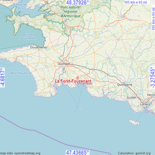
La Forêt-Fouesnant GPS coordinates[2]
47° 54' 36.36" North, 3° 58' 42.888" West
| Map corner | latitude | longitude |
|---|---|---|
| Upper-left | 48.37926°, | -4.6817° |
| Center: | 47.9101°, | -3.97858° |
| Lower-right: | 47.43665°, | -3.27545° |
| Map W x H: | 104.8×104.8 km | = 65.1×65.1mi |
| max Lat: | 51.07786° ⇑42.3% North |
| La Forêt-Fouesnant: | 47.9101° |
| min Lat: | ⇓57.7% South 41.3874° |
| min Long | La Forêt-Foues | max Long |
| -5.08615° | -3.97858° | 9.52242° |
| W 1%⇐ | ⇒99% E |
Elevation
Elevation of La Forêt-Fouesnant is 7 m = 23 ft, and this is 186.7 m = 613 ft below average elevation for this country.
| Max E: |
2333 m = 7654 ft | 98.6% |
| Avg. | 193.7 m = 635 ft | |
| La Forêt-Fouesnant | 7 m = 23 ft | |
Min E: |
-1 m = -3 ft | 1.4% |
See also: France elevation on elevation.city.
Geographical zone
La Forêt-Fouesnant is located in North temperate zone (between Tropic of Cancer and the Arctic Circle). Distance of this North polar circle is 2074.1 km =1288.8 mi to North.| Distance of | km | miles | from La Forêt-Fouesnant |
|---|---|---|---|
| North Pole | 4680 | 2908 | to North |
| Arctic Circle | 2074.1 | 1288.8 | to North |
| Tropic Cancer | 2721.2 | 1690.9 | to South |
| Equator | 5327.1 | 3310.1 | to South |


Nearby cities:
15 places around La Forêt-Fouesnant: (largest is in red/bold)
• Bénodet
10.2 km =6.3 mi,  247°
247°
• Clohars-Fouesnant
6.5 km =4 mi,  256°
256°
• Concarneau
5.7 km =3.5 mi,  132°
132°
• Elliant
11.5 km =7.1 mi,  35°
35°
• Ergué-Gabéric
10 km =6.2 mi,  341°
341°
• Fouesnant
3.4 km =2.1 mi,  233°
233°
• Gouesnach
10.1 km =6.3 mi,  270°
270°
• Melgven
10.7 km =6.6 mi,  92°
92°
• Pleuven
4.2 km =2.6 mi, 254°
• Plomelin
13 km =8.1 mi,  281°
281°
• Quimper
13.5 km =8.4 mi,  317°
317°
• Rosporden
12.5 km =7.8 mi,  59°
59°
• Saint-Yvi
7.1 km =4.4 mi,  28°
28°
• Saint-Évarzec
3.8 km =2.4 mi,  312°
312°
• Trégunc
11.7 km =7.3 mi,  124°
124°
Sources, notices
• [Note1] Compared only with cities in France existing in our database
• [Src1] Map data: © OpenStreetMap contributors (CC-BY-SA)
• [Src2] Other city data from geonames.org with taken over terms of usage.
• [Src3] Geographical zone / Annual Mean Temperature by Robert A. Rohde @ Wikipedia
