Saint-Évarzec geodata
Saint-Évarzec (Brittany) is a populated place; located in France in Europe/Paris (GMT+2) time zone. With population of 3,091 people, there are 3157 cities with bigger population in this country. Compared to other cities in France, 58.1% of cities are located further ↓South; 99% of cities are located further →East and 81.5% of cities have higher elevation than Saint-Évarzec. Note1
Administrative division(s):
- Level 1: Brittany
- Level 2: Département du Finistère
- Level 3: Arrondissement de Quimper
- Level 4: Saint-Évarzec


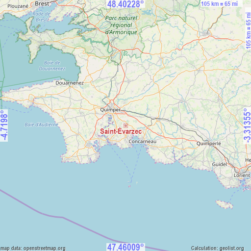
Saint-Évarzec GPS coordinates[2]
47° 55' 59.988" North, 4° 1' 0.012" West
| Map corner | latitude | longitude |
|---|---|---|
| Upper-left | 48.40228°, | -4.7198° |
| Center: | 47.93333°, | -4.01667° |
| Lower-right: | 47.46009°, | -3.31355° |
| Map W x H: | 104.8×104.8 km | = 65.1×65.1mi |
| max Lat: | 51.07786° ⇑41.9% North |
| Saint-Évarzec: | 47.93333° |
| min Lat: | ⇓58.1% South 41.3874° |
| min Long | Saint-Évarzec | max Long |
| -5.08615° | -4.01667° | 9.52242° |
| W 1%⇐ | ⇒99% E |
Elevation
Elevation of Saint-Évarzec is 51 m = 167 ft, and this is 142.7 m = 468 ft below average elevation for this country.
| Max E: |
2333 m = 7654 ft | 81.5% |
| Avg. | 193.7 m = 635 ft | |
| Saint-Évarzec | 51 m = 167 ft | |
Min E: |
-1 m = -3 ft | 18.5% |
See also: France elevation on elevation.city.
Geographical zone
Saint-Évarzec is located in North temperate zone (between Tropic of Cancer and the Arctic Circle). Distance of this North polar circle is 2071.5 km =1287.2 mi to North.| Distance of | km | miles | from Saint-Évarzec |
|---|---|---|---|
| North Pole | 4677.4 | 2906.4 | to North |
| Arctic Circle | 2071.5 | 1287.2 | to North |
| Tropic Cancer | 2723.8 | 1692.5 | to South |
| Equator | 5329.7 | 3311.7 | to South |


Nearby cities:
15 places around Saint-Évarzec: (largest is in red/bold)
• Bénodet
9.3 km =5.8 mi,  225°
225°
• Clohars-Fouesnant
5.4 km =3.4 mi,  220°
220°
• Combrit
11.7 km =7.3 mi,  244°
244°
• Concarneau
9.6 km =6 mi,  132°
132°
• Elliant
11.6 km =7.2 mi,  54°
54°
• Ergué-Gabéric
6.9 km =4.3 mi,  356°
356°
• Fouesnant
4.6 km =2.9 mi,  178°
178°
• Gouesnach
7.7 km =4.8 mi,  250°
250°
• La Forêt-Fouesnant
3.8 km =2.4 mi, 132°
• Melgven
13.9 km =8.6 mi,  102°
102°
• Pleuven
3.9 km =2.4 mi,  198°
198°
• Plomelin
9.9 km =6.2 mi,  270°
270°
• Pluguffan
13.6 km =8.5 mi,  294°
294°
• Quimper
9.7 km =6 mi,  320°
320°
• Saint-Yvi
7.2 km =4.5 mi,  59°
59°
Sources, notices
• [Note1] Compared only with cities in France existing in our database
• [Src1] Map data: © OpenStreetMap contributors (CC-BY-SA)
• [Src2] Other city data from geonames.org with taken over terms of usage.
• [Src3] Geographical zone / Annual Mean Temperature by Robert A. Rohde @ Wikipedia
