La Ferté-Saint-Cyr geodata
La Ferté-Saint-Cyr (Centre) is a populated place; located in France in Europe/Paris (GMT+2) time zone. With population of 922 people, there are 9460 cities with bigger population in this country. Compared to other cities in France, 53.6% of cities are located further ↓South; 60.7% of cities are located further →East and 67% of cities have higher elevation than La Ferté-Saint-Cyr. Note1
Administrative division(s):
- Level 1: Centre
- Level 2: Département du Loir-et-Cher
- Level 3: Arrondissement de Blois
- Level 4: La Ferté-Saint-Cyr


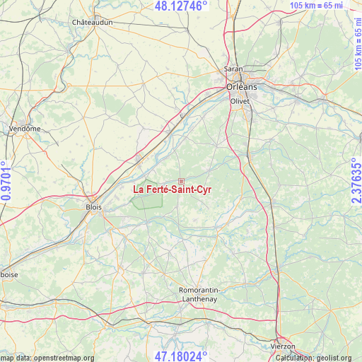
La Ferté-Saint-Cyr GPS coordinates[2]
47° 39' 21.6" North, 1° 40' 23.628" East
| Map corner | latitude | longitude |
|---|---|---|
| Upper-left | 48.12746°, | 0.9701° |
| Center: | 47.656°, | 1.67323° |
| Lower-right: | 47.18024°, | 2.37635° |
| Map W x H: | 105.3×105.3 km | = 65.4×65.4mi |
| max Lat: | 51.07786° ⇑46.4% North |
| La Ferté-Saint-Cyr: | 47.656° |
| min Lat: | ⇓53.6% South 41.3874° |
| min Long | La Ferté-Saint | max Long |
| -5.08615° | 1.67323° | 9.52242° |
| W 39.3%⇐ | ⇒60.7% E |
Elevation
Elevation of La Ferté-Saint-Cyr is 85 m = 279 ft, and this is 108.7 m = 357 ft below average elevation for this country.
| Max E: |
2333 m = 7654 ft | 67% |
| Avg. | 193.7 m = 635 ft | |
| La Ferté-Saint-Cyr | 85 m = 279 ft | |
Min E: |
-1 m = -3 ft | 33% |
See also: France elevation on elevation.city.
Geographical zone
La Ferté-Saint-Cyr is located in North temperate zone (between Tropic of Cancer and the Arctic Circle). Distance of this North polar circle is 2102.3 km =1306.3 mi to North.| Distance of | km | miles | from La Ferté-Saint-Cyr |
|---|---|---|---|
| North Pole | 4708.2 | 2925.5 | to North |
| Arctic Circle | 2102.3 | 1306.3 | to North |
| Tropic Cancer | 2692.9 | 1673.3 | to South |
| Equator | 5298.9 | 3292.6 | to South |


Nearby cities:
15 places around La Ferté-Saint-Cyr: (largest is in red/bold)
• Avaray
11 km =6.8 mi,  312°
312°
• Beaugency
14.2 km =8.8 mi,  345°
345°
• Crouy-sur-Cosson
4.8 km =3 mi,  262°
262°
• Dhuizon
7.7 km =4.8 mi,  188°
188°
• Jouy-le-Potier
14.3 km =8.9 mi,  46°
46°
• Lailly-en-Val
12.7 km =7.9 mi,  4°
4°
• Ligny-le-Ribault
8.7 km =5.4 mi,  68°
68°
• Maslives
14.7 km =9.1 mi, 260°
• Mer
13.7 km =8.5 mi,  293°
293°
• Montrieux-en-Sologne
12 km =7.5 mi,  160°
160°
• Muides-sur-Loire
11.1 km =6.9 mi,  277°
277°
• Saint-Dyé-sur-Loire
13.8 km =8.6 mi,  269°
269°
• Saint-Laurent-Nouan
8.7 km =5.4 mi,  320°
320°
• Tavers
12.3 km =7.6 mi,  338°
338°
• Yvoy-le-Marron
13.7 km =8.5 mi,  101°
101°
Sources, notices
• [Note1] Compared only with cities in France existing in our database
• [Src1] Map data: © OpenStreetMap contributors (CC-BY-SA)
• [Src2] Other city data from geonames.org with taken over terms of usage.
• [Src3] Geographical zone / Annual Mean Temperature by Robert A. Rohde @ Wikipedia
