Crouy-sur-Cosson geodata
Crouy-sur-Cosson (Centre) is a populated place; located in France in Europe/Paris (GMT+2) time zone. With population of 574 people, there are 13763 cities with bigger population in this country. Compared to other cities in France, 53.4% of cities are located further ↓South; 61.6% of cities are located further →East and 66% of cities have higher elevation than Crouy-sur-Cosson. Note1
Administrative division(s):
- Level 1: Centre
- Level 2: Département du Loir-et-Cher
- Level 3: Arrondissement de Blois
- Level 4: Crouy-sur-Cosson


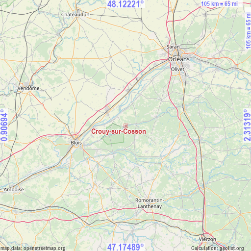
Crouy-sur-Cosson GPS coordinates[2]
47° 39' 2.52" North, 1° 36' 36.252" East
| Map corner | latitude | longitude |
|---|---|---|
| Upper-left | 48.12221°, | 0.90694° |
| Center: | 47.6507°, | 1.61007° |
| Lower-right: | 47.17489°, | 2.31319° |
| Map W x H: | 105.3×105.3 km | = 65.4×65.4mi |
| max Lat: | 51.07786° ⇑46.6% North |
| Crouy-sur-Cosson: | 47.6507° |
| min Lat: | ⇓53.4% South 41.3874° |
| min Long | Crouy-sur-Cosso | max Long |
| -5.08615° | 1.61007° | 9.52242° |
| W 38.4%⇐ | ⇒61.6% E |
Elevation
Elevation of Crouy-sur-Cosson is 87 m = 285 ft, and this is 106.7 m = 350 ft below average elevation for this country.
| Max E: |
2333 m = 7654 ft | 66% |
| Avg. | 193.7 m = 635 ft | |
| Crouy-sur-Cosson | 87 m = 285 ft | |
Min E: |
-1 m = -3 ft | 34% |
See also: France elevation on elevation.city.
Geographical zone
Crouy-sur-Cosson is located in North temperate zone (between Tropic of Cancer and the Arctic Circle). Distance of this North polar circle is 2102.9 km =1306.7 mi to North.| Distance of | km | miles | from Crouy-sur-Cosson |
|---|---|---|---|
| North Pole | 4708.8 | 2925.9 | to North |
| Arctic Circle | 2102.9 | 1306.7 | to North |
| Tropic Cancer | 2692.3 | 1672.9 | to South |
| Equator | 5298.3 | 3292.2 | to South |


Nearby cities:
15 places around Crouy-sur-Cosson: (largest is in red/bold)
• Avaray
8.7 km =5.4 mi,  336°
336°
• Bracieux
12.4 km =7.7 mi,  204°
204°
• Dhuizon
7.9 km =4.9 mi,  152°
152°
• Huisseau-sur-Cosson
13.4 km =8.3 mi,  241°
241°
• La Ferté-Saint-Cyr
4.8 km =3 mi,  82°
82°
• Ligny-le-Ribault
13.4 km =8.3 mi,  73°
73°
• Maslives
10 km =6.2 mi,  258°
258°
• Mer
9.9 km =6.2 mi,  308°
308°
• Montlivault
12.4 km =7.7 mi, 264°
• Montrieux-en-Sologne
13.8 km =8.6 mi,  141°
141°
• Muides-sur-Loire
6.6 km =4.1 mi,  288°
288°
• Saint-Dyé-sur-Loire
9.1 km =5.7 mi,  273°
273°
• Saint-Laurent-Nouan
7.4 km =4.6 mi,  354°
354°
• Suèvres
11.3 km =7 mi,  279°
279°
• Tavers
12.1 km =7.5 mi,  0°
0°
Sources, notices
• [Note1] Compared only with cities in France existing in our database
• [Src1] Map data: © OpenStreetMap contributors (CC-BY-SA)
• [Src2] Other city data from geonames.org with taken over terms of usage.
• [Src3] Geographical zone / Annual Mean Temperature by Robert A. Rohde @ Wikipedia
