Saint-Fiacre-sur-Maine geodata
Saint-Fiacre-sur-Maine (Pays de la Loire) is a populated place; located in France in Europe/Paris (GMT+2) time zone. With population of 1,071 people, there are 8327 cities with bigger population in this country. Compared to other cities in France, 53.7% of cities are located further ↑North; 91.6% of cities are located further →East and 86.2% of cities have higher elevation than Saint-Fiacre-sur-Maine. Note1
Administrative division(s):
- Level 1: Pays de la Loire
- Level 2: Loire-Atlantique
- Level 3: Arrondissement de Nantes
- Level 4: Saint-Fiacre-sur-Maine


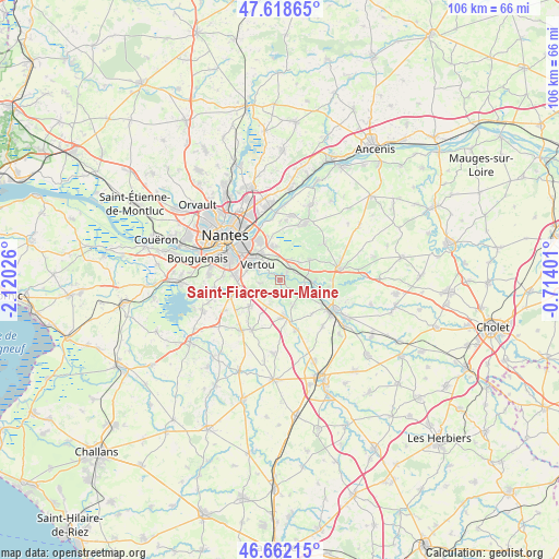
Saint-Fiacre-sur-Maine GPS coordinates[2]
47° 8' 33.18" North, 1° 25' 1.704" West
| Map corner | latitude | longitude |
|---|---|---|
| Upper-left | 47.61865°, | -2.12026° |
| Center: | 47.14255°, | -1.41714° |
| Lower-right: | 46.66215°, | -0.71401° |
| Map W x H: | 106.4×106.4 km | = 66.1×66.1mi |
| max Lat: | 51.07786° ⇑53.7% North |
| Saint-Fiacre-sur-Maine: | 47.14255° |
| min Lat: | ⇓46.3% South 41.3874° |
| min Long | Saint-Fiacre-su | max Long |
| -5.08615° | -1.41714° | 9.52242° |
| W 8.4%⇐ | ⇒91.6% E |
Elevation
Elevation of Saint-Fiacre-sur-Maine is 39 m = 128 ft, and this is 154.7 m = 508 ft below average elevation for this country.
| Max E: |
2333 m = 7654 ft | 86.2% |
| Avg. | 193.7 m = 635 ft | |
| Saint-Fiacre-sur-Maine | 39 m = 128 ft | |
Min E: |
-1 m = -3 ft | 13.8% |
See also: France elevation on elevation.city.
Geographical zone
Saint-Fiacre-sur-Maine is located in North temperate zone (between Tropic of Cancer and the Arctic Circle). Distance of this North polar circle is 2159.4 km =1341.8 mi to North.| Distance of | km | miles | from Saint-Fiacre-sur-Maine |
|---|---|---|---|
| North Pole | 4765.3 | 2961 | to North |
| Arctic Circle | 2159.4 | 1341.8 | to North |
| Tropic Cancer | 2635.8 | 1637.8 | to South |
| Equator | 5241.8 | 3257.1 | to South |


Nearby cities:
15 places around Saint-Fiacre-sur-Maine: (largest is in red/bold)
• Aigrefeuille-sur-Maine
7.2 km =4.5 mi,  171°
171°
• Basse-Goulaine
8.6 km =5.3 mi,  333°
333°
• Gorges
10.1 km =6.3 mi,  118°
118°
• Haute-Goulaine
6.4 km =4 mi,  351°
351°
• La Chapelle-Heulin
7 km =4.3 mi,  56°
56°
• La Haie-Fouassière
2 km =1.2 mi,  46°
46°
• Le Bignon
7.6 km =4.7 mi,  228°
228°
• Le Pallet
6.3 km =3.9 mi,  94°
94°
• Les Sorinières
8.5 km =5.3 mi,  274°
274°
• Maisdon-sur-Sèvre
5.8 km =3.6 mi,  150°
150°
• Monnières
5 km =3.1 mi,  102°
102°
• Remouillé
10.1 km =6.3 mi,  162°
162°
• Saint-Lumine-de-Clisson
9 km =5.6 mi,  136°
136°
• Saint-Sébastien-sur-Loire
9.7 km =6 mi,  318°
318°
• Vertou
4.9 km =3 mi,  306°
306°
Sources, notices
• [Note1] Compared only with cities in France existing in our database
• [Src1] Map data: © OpenStreetMap contributors (CC-BY-SA)
• [Src2] Other city data from geonames.org with taken over terms of usage.
• [Src3] Geographical zone / Annual Mean Temperature by Robert A. Rohde @ Wikipedia
