Vertou geodata
Vertou (Pays de la Loire) is a populated place; located in France in Europe/Paris (GMT+2) time zone. With population of 22,921 people, there are 391 cities with bigger population in this country. Compared to other cities in France, 53.4% of cities are located further ↑North; 92% of cities are located further →East and 89.1% of cities have higher elevation than Vertou. Note1
Administrative division(s):
- Level 1: Pays de la Loire
- Level 2: Loire-Atlantique
- Level 3: Arrondissement de Nantes
- Level 4: Vertou


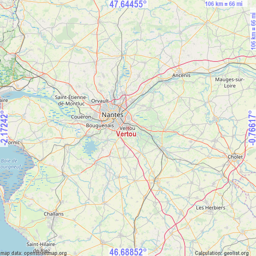
Vertou GPS coordinates[2]
47° 10' 7.284" North, 1° 28' 9.444" West
| Map corner | latitude | longitude |
|---|---|---|
| Upper-left | 47.64455°, | -2.17242° |
| Center: | 47.16869°, | -1.46929° |
| Lower-right: | 46.68852°, | -0.76617° |
| Map W x H: | 106.3×106.3 km | = 66.1×66.1mi |
| max Lat: | 51.07786° ⇑53.4% North |
| Vertou: | 47.16869° |
| min Lat: | ⇓46.6% South 41.3874° |
| min Long | Vertou | max Long |
| -5.08615° | -1.46929° | 9.52242° |
| W 8%⇐ | ⇒92% E |
Elevation
Elevation of Vertou is 32 m = 105 ft, and this is 161.7 m = 531 ft below average elevation for this country.
| Max E: |
2333 m = 7654 ft | 89.1% |
| Avg. | 193.7 m = 635 ft | |
| Vertou | 32 m = 105 ft | |
Min E: |
-1 m = -3 ft | 10.9% |
See also: France elevation on elevation.city.
Geographical zone
Vertou is located in North temperate zone (between Tropic of Cancer and the Arctic Circle). Distance of this North polar circle is 2156.5 km =1340 mi to North.| Distance of | km | miles | from Vertou |
|---|---|---|---|
| North Pole | 4762.4 | 2959.2 | to North |
| Arctic Circle | 2156.5 | 1340 | to North |
| Tropic Cancer | 2638.7 | 1639.6 | to South |
| Equator | 5244.7 | 3258.9 | to South |


Nearby cities:
15 places around Vertou: (largest is in red/bold)
• Basse-Goulaine
4.8 km =3 mi,  1°
1°
• Haute-Goulaine
4.5 km =2.8 mi,  41°
41°
• La Chapelle-Heulin
9.8 km =6.1 mi,  84°
84°
• La Haie-Fouassière
5.6 km =3.5 mi,  105°
105°
• Le Bignon
8.1 km =5 mi,  192°
192°
• Le Pallet
10.7 km =6.6 mi, 108°
• Les Sorinières
5.1 km =3.2 mi,  243°
243°
• Maisdon-sur-Sèvre
10.4 km =6.5 mi,  139°
139°
• Monnières
9.6 km =6 mi, 114°
• Nantes
8.3 km =5.2 mi,  310°
310°
• Pont-Saint-Martin
10.1 km =6.3 mi, 239°
• Rezé
6.2 km =3.9 mi,  283°
283°
• Saint-Fiacre-sur-Maine
4.9 km =3 mi,  126°
126°
• Saint-Sébastien-sur-Loire
5 km =3.1 mi,  329°
329°
• Sainte-Luce-sur-Loire
9.5 km =5.9 mi,  353°
353°
Sources, notices
• [Note1] Compared only with cities in France existing in our database
• [Src1] Map data: © OpenStreetMap contributors (CC-BY-SA)
• [Src2] Other city data from geonames.org with taken over terms of usage.
• [Src3] Geographical zone / Annual Mean Temperature by Robert A. Rohde @ Wikipedia
