La Chaize-le-Vicomte geodata
La Chaize-le-Vicomte (Pays de la Loire) is a populated place; located in France in Europe/Paris (GMT+2) time zone. With population of 2,858 people, there are 3413 cities with bigger population in this country. Compared to other cities in France, 58.5% of cities are located further ↑North; 90.7% of cities are located further →East and 68.3% of cities have higher elevation than La Chaize-le-Vicomte. Note1
Administrative division(s):
- Level 1: Pays de la Loire
- Level 2: Département de la Vendée
- Level 3: Arrondissement de La Roche-sur-Yon
- Level 4: La Chaize-le-Vicomte


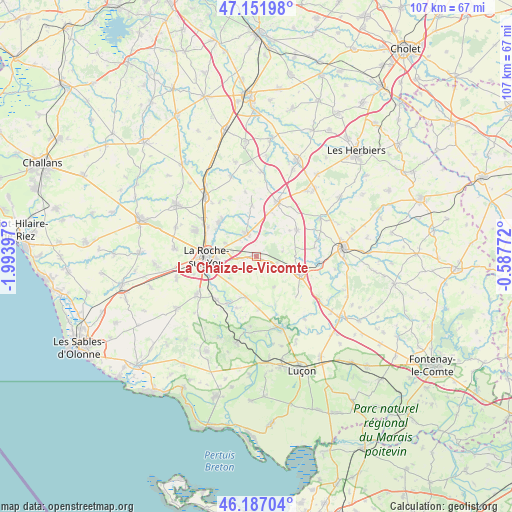
La Chaize-le-Vicomte GPS coordinates[2]
46° 40' 17.976" North, 1° 17' 27.024" West
| Map corner | latitude | longitude |
|---|---|---|
| Upper-left | 47.15198°, | -1.99397° |
| Center: | 46.67166°, | -1.29084° |
| Lower-right: | 46.18704°, | -0.58772° |
| Map W x H: | 107.3×107.3 km | = 66.7×66.7mi |
| max Lat: | 51.07786° ⇑58.5% North |
| La Chaize-le-Vicomte: | 46.67166° |
| min Lat: | ⇓41.5% South 41.3874° |
| min Long | La Chaize-le-Vi | max Long |
| -5.08615° | -1.29084° | 9.52242° |
| W 9.3%⇐ | ⇒90.7% E |
Elevation
Elevation of La Chaize-le-Vicomte is 82 m = 269 ft, and this is 111.7 m = 366 ft below average elevation for this country.
| Max E: |
2333 m = 7654 ft | 68.3% |
| Avg. | 193.7 m = 635 ft | |
| La Chaize-le-Vicomte | 82 m = 269 ft | |
Min E: |
-1 m = -3 ft | 31.7% |
See also: France elevation on elevation.city.
Geographical zone
La Chaize-le-Vicomte is located in North temperate zone (between Tropic of Cancer and the Arctic Circle). Distance of this North polar circle is 2211.8 km =1374.3 mi to North.| Distance of | km | miles | from La Chaize-le-Vicomte |
|---|---|---|---|
| North Pole | 4817.7 | 2993.6 | to North |
| Arctic Circle | 2211.8 | 1374.3 | to North |
| Tropic Cancer | 2583.5 | 1605.3 | to South |
| Equator | 5189.4 | 3224.5 | to South |


Nearby cities:
15 places around La Chaize-le-Vicomte: (largest is in red/bold)
• Boulogne
13.7 km =8.5 mi,  350°
350°
• Bournezeau
9.9 km =6.2 mi,  112°
112°
• Château-Guibert
10.9 km =6.8 mi,  157°
157°
• Dompierre-sur-Yon
10.3 km =6.4 mi,  316°
316°
• Fougeré
4.7 km =2.9 mi, 107°
• La Ferrière
5.1 km =3.2 mi,  339°
339°
• La Merlatière
10.8 km =6.7 mi,  355°
355°
• La Roche-sur-Yon
10.9 km =6.8 mi,  267°
267°
• Les Essarts
12.4 km =7.7 mi,  22°
22°
• Mouilleron-le-Captif
13.6 km =8.5 mi,  292°
292°
• Nesmy
12.3 km =7.6 mi,  223°
223°
• Saint-Florent-des-Bois
8.9 km =5.5 mi,  192°
192°
• Saint-Hilaire-le-Vouhis
12.4 km =7.7 mi,  81°
81°
• Saint-Martin-des-Noyers
10.3 km =6.4 mi,  56°
56°
• Thorigny
7.6 km =4.7 mi,  149°
149°
Sources, notices
• [Note1] Compared only with cities in France existing in our database
• [Src1] Map data: © OpenStreetMap contributors (CC-BY-SA)
• [Src2] Other city data from geonames.org with taken over terms of usage.
• [Src3] Geographical zone / Annual Mean Temperature by Robert A. Rohde @ Wikipedia
