Thorigny geodata
Thorigny (Pays de la Loire) is a populated place; located in France in Europe/Paris (GMT+2) time zone. With population of 933 people, there are 9360 cities with bigger population in this country. Compared to other cities in France, 59.1% of cities are located further ↑North; 90.3% of cities are located further →East and 79% of cities have higher elevation than Thorigny. Note1
Administrative division(s):
- Level 1: Pays de la Loire
- Level 2: Département de la Vendée
- Level 3: Arrondissement de La Roche-sur-Yon
- Level 4: Thorigny


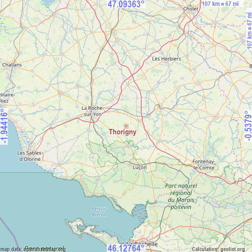
Thorigny GPS coordinates[2]
46° 36' 46.044" North, 1° 14' 27.708" West
| Map corner | latitude | longitude |
|---|---|---|
| Upper-left | 47.09363°, | -1.94416° |
| Center: | 46.61279°, | -1.24103° |
| Lower-right: | 46.12764°, | -0.5379° |
| Map W x H: | 107.4×107.4 km | = 66.7×66.7mi |
| max Lat: | 51.07786° ⇑59.1% North |
| Thorigny: | 46.61279° |
| min Lat: | ⇓40.9% South 41.3874° |
| min Long | Thorigny | max Long |
| -5.08615° | -1.24103° | 9.52242° |
| W 9.7%⇐ | ⇒90.3% E |
Elevation
Elevation of Thorigny is 57 m = 187 ft, and this is 136.7 m = 448 ft below average elevation for this country.
| Max E: |
2333 m = 7654 ft | 79% |
| Avg. | 193.7 m = 635 ft | |
| Thorigny | 57 m = 187 ft | |
Min E: |
-1 m = -3 ft | 21% |
See also: France elevation on elevation.city.
Geographical zone
Thorigny is located in North temperate zone (between Tropic of Cancer and the Arctic Circle). Distance of this North polar circle is 2218.3 km =1378.4 mi to North.| Distance of | km | miles | from Thorigny |
|---|---|---|---|
| North Pole | 4824.2 | 2997.6 | to North |
| Arctic Circle | 2218.3 | 1378.4 | to North |
| Tropic Cancer | 2576.9 | 1601.2 | to South |
| Equator | 5182.9 | 3220.5 | to South |


Nearby cities:
15 places around Thorigny: (largest is in red/bold)
• Bournezeau
6 km =3.7 mi,  63°
63°
• Château-Guibert
3.5 km =2.2 mi,  174°
174°
• Corpe
12.8 km =8 mi,  159°
159°
• Fougeré
5.2 km =3.2 mi,  7°
7°
• La Chaize-le-Vicomte
7.6 km =4.7 mi,  329°
329°
• La Ferrière
12.6 km =7.8 mi, 333°
• Le Champ-Saint-Père
14.2 km =8.8 mi,  214°
214°
• Les Magnils-Reigniers
14.5 km =9 mi, 172°
• Mareuil-sur-Lay-Dissais
8.9 km =5.5 mi,  176°
176°
• Moutiers-sur-le-Lay
9.1 km =5.7 mi,  135°
135°
• Nesmy
12.4 km =7.7 mi,  258°
258°
• Péault
12.4 km =7.7 mi, 172°
• Saint-Florent-des-Bois
6.1 km =3.8 mi,  249°
249°
• Saint-Hilaire-le-Vouhis
11.9 km =7.4 mi,  45°
45°
• Saint-Martin-des-Noyers
13.1 km =8.1 mi,  21°
21°
Sources, notices
• [Note1] Compared only with cities in France existing in our database
• [Src1] Map data: © OpenStreetMap contributors (CC-BY-SA)
• [Src2] Other city data from geonames.org with taken over terms of usage.
• [Src3] Geographical zone / Annual Mean Temperature by Robert A. Rohde @ Wikipedia
