Bournezeau geodata
Bournezeau (Pays de la Loire) is a populated place; located in France in Europe/Paris (GMT+2) time zone. With population of 2,755 people, there are 3550 cities with bigger population in this country. Compared to other cities in France, 58.9% of cities are located further ↑North; 89.8% of cities are located further →East and 69.7% of cities have higher elevation than Bournezeau. Note1
Administrative division(s):
- Level 1: Pays de la Loire
- Level 2: Département de la Vendée
- Level 3: Arrondissement de La Roche-sur-Yon
- Level 4: Bournezeau


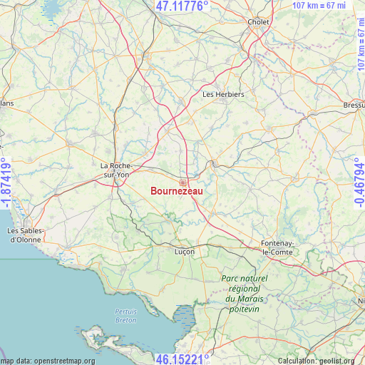
Bournezeau GPS coordinates[2]
46° 38' 13.704" North, 1° 10' 15.852" West
| Map corner | latitude | longitude |
|---|---|---|
| Upper-left | 47.11776°, | -1.87419° |
| Center: | 46.63714°, | -1.17107° |
| Lower-right: | 46.15221°, | -0.46794° |
| Map W x H: | 107.4×107.4 km | = 66.7×66.7mi |
| max Lat: | 51.07786° ⇑58.9% North |
| Bournezeau: | 46.63714° |
| min Lat: | ⇓41.1% South 41.3874° |
| min Long | Bournezeau | max Long |
| -5.08615° | -1.17107° | 9.52242° |
| W 10.2%⇐ | ⇒89.8% E |
Elevation
Elevation of Bournezeau is 79 m = 259 ft, and this is 114.7 m = 376 ft below average elevation for this country.
| Max E: |
2333 m = 7654 ft | 69.7% |
| Avg. | 193.7 m = 635 ft | |
| Bournezeau | 79 m = 259 ft | |
Min E: |
-1 m = -3 ft | 30.3% |
See also: France elevation on elevation.city.
Geographical zone
Bournezeau is located in North temperate zone (between Tropic of Cancer and the Arctic Circle). Distance of this North polar circle is 2215.6 km =1376.7 mi to North.| Distance of | km | miles | from Bournezeau |
|---|---|---|---|
| North Pole | 4821.5 | 2995.9 | to North |
| Arctic Circle | 2215.6 | 1376.7 | to North |
| Tropic Cancer | 2579.6 | 1602.9 | to South |
| Equator | 5185.6 | 3222.2 | to South |


Nearby cities:
15 places around Bournezeau: (largest is in red/bold)
• Chantonnay
10.8 km =6.7 mi,  58°
58°
• Château-Guibert
8 km =5 mi,  218°
218°
• Fougeré
5.2 km =3.2 mi,  297°
297°
• La Chaize-le-Vicomte
9.9 km =6.2 mi,  292°
292°
• La Ferrière
13.9 km =8.6 mi,  308°
308°
• La Réorthe
9.9 km =6.2 mi,  109°
109°
• Mareuil-sur-Lay-Dissais
12.5 km =7.8 mi,  202°
202°
• Moutiers-sur-le-Lay
9.3 km =5.8 mi,  173°
173°
• Saint-Florent-des-Bois
12.1 km =7.5 mi,  246°
246°
• Saint-Hilaire-le-Vouhis
6.4 km =4 mi,  28°
28°
• Saint-Martin-des-Noyers
9.5 km =5.9 mi,  357°
357°
• Saint-Vincent-Sterlanges
13.1 km =8.1 mi, 28°
• Sainte-Cécile
12.5 km =7.8 mi,  20°
20°
• Sainte-Hermine
12.6 km =7.8 mi,  135°
135°
• Thorigny
6 km =3.7 mi,  243°
243°
Sources, notices
• [Note1] Compared only with cities in France existing in our database
• [Src1] Map data: © OpenStreetMap contributors (CC-BY-SA)
• [Src2] Other city data from geonames.org with taken over terms of usage.
• [Src3] Geographical zone / Annual Mean Temperature by Robert A. Rohde @ Wikipedia
