La Boissière-École geodata
La Boissière-École (Île-de-France) is a populated place; located in France in Europe/Paris (GMT+2) time zone. With population of 762 people, there are 11040 cities with bigger population in this country. Compared to other cities in France, 72.7% of cities are located further ↓South; 61% of cities are located further →East and 52.2% of cities have lower elevation than La Boissière-École. Note1
Administrative division(s):
- Level 1: Île-de-France
- Level 2: Yvelines
- Level 3: Arrondissement de Rambouillet
- Level 4: La Boissière-École


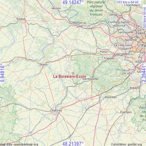
La Boissière-École GPS coordinates[2]
48° 40' 49.296" North, 1° 39' 4.608" East
| Map corner | latitude | longitude |
|---|---|---|
| Upper-left | 49.14247°, | 0.94816° |
| Center: | 48.68036°, | 1.65128° |
| Lower-right: | 48.21397°, | 2.35441° |
| Map W x H: | 103.2×103.2 km | = 64.1×64.1mi |
| max Lat: | 51.07786° ⇑27.3% North |
| La Boissière-École: | 48.68036° |
| min Lat: | ⇓72.7% South 41.3874° |
| min Long | La Boissière-� | max Long |
| -5.08615° | 1.65128° | 9.52242° |
| W 39%⇐ | ⇒61% E |
Elevation
Elevation of La Boissière-École is 140 m = 459 ft, and this is 53.7 m = 176 ft below average elevation for this country.
| Max E: |
2333 m = 7654 ft | 47.8% |
| Avg. | 193.7 m = 635 ft | |
| La Boissière-École | 140 m = 459 ft | |
Min E: |
-1 m = -3 ft | 52.2% |
See also: France elevation on elevation.city.
Geographical zone
La Boissière-École is located in North temperate zone (between Tropic of Cancer and the Arctic Circle). Distance of this North polar circle is 1988.4 km =1235.5 mi to North.| Distance of | km | miles | from La Boissière-École |
|---|---|---|---|
| North Pole | 4594.3 | 2854.8 | to North |
| Arctic Circle | 1988.4 | 1235.5 | to North |
| Tropic Cancer | 2806.8 | 1744.1 | to South |
| Equator | 5412.7 | 3363.3 | to South |


Nearby cities:
15 places around La Boissière-École: (largest is in red/bold)
• Adainville
4.8 km =3 mi,  1°
1°
• Condé-sur-Vesgre
6.9 km =4.3 mi,  5°
5°
• Coulombs
8.3 km =5.2 mi,  248°
248°
• Droue-sur-Drouette
9.6 km =6 mi,  157°
157°
• Hanches
8.8 km =5.5 mi,  179°
179°
• Lormaye
9.3 km =5.8 mi, 248°
• Mittainville
1.1 km =0.7 mi,  198°
198°
• Poigny-la-Forêt
7.7 km =4.8 mi,  90°
90°
• Raizeux
6.6 km =4.1 mi, 159°
• Saint-Hilarion
9 km =5.6 mi,  137°
137°
• Saint-Léger-en-Yvelines
9.6 km =6 mi,  61°
61°
• Saint-Martin-de-Nigelles
8.2 km =5.1 mi, 202°
• Senantes
6.4 km =4 mi,  256°
256°
• Villiers-le-Morhier
9.3 km =5.8 mi,  223°
223°
• Épernon
7.9 km =4.9 mi,  168°
168°
Sources, notices
• [Note1] Compared only with cities in France existing in our database
• [Src1] Map data: © OpenStreetMap contributors (CC-BY-SA)
• [Src2] Other city data from geonames.org with taken over terms of usage.
• [Src3] Geographical zone / Annual Mean Temperature by Robert A. Rohde @ Wikipedia
