Kœtzingue geodata
Kœtzingue (Grand Est) is a populated place; located in France in Europe/Paris (GMT+2) time zone. With population of 518 people, there are 14866 cities with bigger population in this country. Compared to other cities in France, 53.4% of cities are located further ↓South; 97.2% of cities are located further ←West and 80.4% of cities have lower elevation than Kœtzingue. Note1
Administrative division(s):
- Level 1: Grand Est
- Level 2: Haut-Rhin
- Level 3: Arrondissement de Mulhouse
- Level 4: Kœtzingue


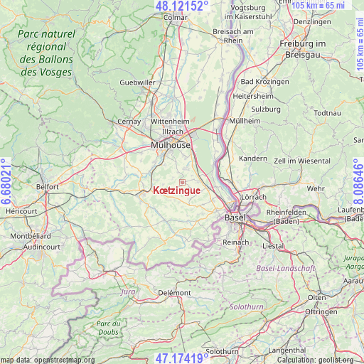
Kœtzingue GPS coordinates[2]
47° 39' 0" North, 7° 22' 59.988" East
| Map corner | latitude | longitude |
|---|---|---|
| Upper-left | 48.12152°, | 6.68021° |
| Center: | 47.65°, | 7.38333° |
| Lower-right: | 47.17419°, | 8.08646° |
| Map W x H: | 105.3×105.3 km | = 65.4×65.4mi |
| max Lat: | 51.07786° ⇑46.6% North |
| Kœtzingue: | 47.65° |
| min Lat: | ⇓53.4% South 41.3874° |
| min Long | Kœtzingue | max Long |
| -5.08615° | 7.38333° | 9.52242° |
| W 97.2%⇐ | ⇒2.8% E |
Elevation
Elevation of Kœtzingue is 295 m = 968 ft, and this is 101.3 m = 332 ft above average elevation for this country.
| Max E: |
2333 m = 7654 ft | 19.6% |
| Kœtzingue | 295 m 968 ft | |
| Avg. | 193.7 m = 635 ft | |
Min E: |
-1 m = -3 ft | 80.4% |
See also: France elevation on elevation.city.
Geographical zone
Kœtzingue is located in North temperate zone (between Tropic of Cancer and the Arctic Circle). Distance of this North polar circle is 2103 km =1306.7 mi to North.| Distance of | km | miles | from Kœtzingue |
|---|---|---|---|
| North Pole | 4708.9 | 2926 | to North |
| Arctic Circle | 2103 | 1306.7 | to North |
| Tropic Cancer | 2692.3 | 1672.9 | to South |
| Equator | 5298.2 | 3292.1 | to South |


Nearby cities:
15 places around Kœtzingue: (largest is in red/bold)
• Bruebach
5.9 km =3.7 mi,  342°
342°
• Dietwiller
5 km =3.1 mi,  17°
17°
• Eschentzwiller
7.1 km =4.4 mi,  8°
8°
• Helfrantzkirch
5.4 km =3.4 mi,  153°
153°
• Jettingen
5.8 km =3.6 mi,  187°
187°
• Kappelen
5.4 km =3.4 mi,  129°
129°
• Landser
3.9 km =2.4 mi, 7°
• Luemschwiller
7.2 km =4.5 mi,  274°
274°
• Rantzwiller
0.7 km =0.4 mi,  293°
293°
• Schlierbach
4.1 km =2.5 mi,  26°
26°
• Sierentz
5.4 km =3.4 mi,  80°
80°
• Steinbrunn-le-Bas
3.1 km =1.9 mi, 336°
• Steinbrunn-le-Haut
2.9 km =1.8 mi, 293°
• Uffheim
4.4 km =2.7 mi,  89°
89°
• Waltenheim
3.3 km =2.1 mi, 75°
Sources, notices
• [Note1] Compared only with cities in France existing in our database
• [Src1] Map data: © OpenStreetMap contributors (CC-BY-SA)
• [Src2] Other city data from geonames.org with taken over terms of usage.
• [Src3] Geographical zone / Annual Mean Temperature by Robert A. Rohde @ Wikipedia
