Schlierbach geodata
Schlierbach (Grand Est) is a populated place; located in France in Europe/Paris (GMT+2) time zone. With population of 977 people, there are 9003 cities with bigger population in this country. Compared to other cities in France, 53.9% of cities are located further ↓South; 97.3% of cities are located further ←West and 78.5% of cities have lower elevation than Schlierbach. Note1
Administrative division(s):
- Level 1: Grand Est
- Level 2: Haut-Rhin
- Level 3: Arrondissement de Mulhouse
- Level 4: Schlierbach


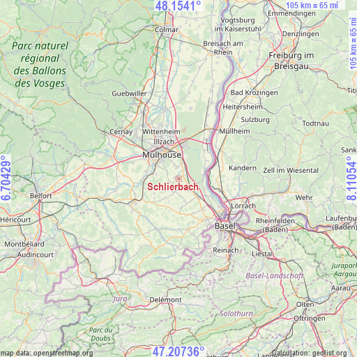
Schlierbach GPS coordinates[2]
47° 40' 58.368" North, 7° 24' 26.712" East
| Map corner | latitude | longitude |
|---|---|---|
| Upper-left | 48.1541°, | 6.70429° |
| Center: | 47.68288°, | 7.40742° |
| Lower-right: | 47.20736°, | 8.11054° |
| Map W x H: | 105.3×105.3 km | = 65.4×65.4mi |
| max Lat: | 51.07786° ⇑46.1% North |
| Schlierbach: | 47.68288° |
| min Lat: | ⇓53.9% South 41.3874° |
| min Long | Schlierbach | max Long |
| -5.08615° | 7.40742° | 9.52242° |
| W 97.3%⇐ | ⇒2.7% E |
Elevation
Elevation of Schlierbach is 276 m = 906 ft, and this is 82.3 m = 270 ft above average elevation for this country.
| Max E: |
2333 m = 7654 ft | 21.5% |
| Schlierbach | 276 m 906 ft | |
| Avg. | 193.7 m = 635 ft | |
Min E: |
-1 m = -3 ft | 78.5% |
See also: France elevation on elevation.city.
Geographical zone
Schlierbach is located in North temperate zone (between Tropic of Cancer and the Arctic Circle). Distance of this North polar circle is 2099.3 km =1304.4 mi to North.| Distance of | km | miles | from Schlierbach |
|---|---|---|---|
| North Pole | 4705.2 | 2923.7 | to North |
| Arctic Circle | 2099.3 | 1304.4 | to North |
| Tropic Cancer | 2695.9 | 1675.2 | to South |
| Equator | 5301.8 | 3294.4 | to South |


Nearby cities:
15 places around Schlierbach: (largest is in red/bold)
• Bruebach
4.1 km =2.5 mi,  298°
298°
• Dietwiller
1.1 km =0.7 mi,  343°
343°
• Eschentzwiller
3.4 km =2.1 mi,  347°
347°
• Flaxlanden
7.1 km =4.4 mi,  281°
281°
• Habsheim
5.3 km =3.3 mi,  8°
8°
• Kembs
7.2 km =4.5 mi,  84°
84°
• Kœtzingue
4.1 km =2.5 mi,  206°
206°
• Landser
1.3 km =0.8 mi, 280°
• Rantzwiller
4.2 km =2.6 mi,  215°
215°
• Sierentz
4.4 km =2.7 mi,  128°
128°
• Steinbrunn-le-Bas
3.1 km =1.9 mi,  254°
254°
• Steinbrunn-le-Haut
5.1 km =3.2 mi,  240°
240°
• Uffheim
4.5 km =2.8 mi,  144°
144°
• Waltenheim
3.1 km =1.9 mi,  154°
154°
• Zimmersheim
4.4 km =2.7 mi, 341°
Sources, notices
• [Note1] Compared only with cities in France existing in our database
• [Src1] Map data: © OpenStreetMap contributors (CC-BY-SA)
• [Src2] Other city data from geonames.org with taken over terms of usage.
• [Src3] Geographical zone / Annual Mean Temperature by Robert A. Rohde @ Wikipedia
