Uffheim geodata
Uffheim (Grand Est) is a populated place; located in France in Europe/Paris (GMT+2) time zone. With population of 901 people, there are 9647 cities with bigger population in this country. Compared to other cities in France, 53.4% of cities are located further ↓South; 97.5% of cities are located further ←West and 78.1% of cities have lower elevation than Uffheim. Note1
Administrative division(s):
- Level 1: Grand Est
- Level 2: Haut-Rhin
- Level 3: Arrondissement de Mulhouse
- Level 4: Uffheim


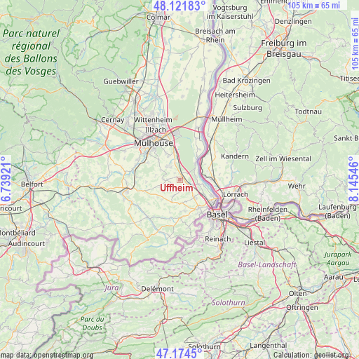
Uffheim GPS coordinates[2]
47° 39' 1.116" North, 7° 26' 32.388" East
| Map corner | latitude | longitude |
|---|---|---|
| Upper-left | 48.12183°, | 6.73921° |
| Center: | 47.65031°, | 7.44233° |
| Lower-right: | 47.1745°, | 8.14546° |
| Map W x H: | 105.3×105.3 km | = 65.4×65.4mi |
| max Lat: | 51.07786° ⇑46.6% North |
| Uffheim: | 47.65031° |
| min Lat: | ⇓53.4% South 41.3874° |
| min Long | Uffheim | max Long |
| -5.08615° | 7.44233° | 9.52242° |
| W 97.5%⇐ | ⇒2.5% E |
Elevation
Elevation of Uffheim is 273 m = 896 ft, and this is 79.3 m = 260 ft above average elevation for this country.
| Max E: |
2333 m = 7654 ft | 21.9% |
| Uffheim | 273 m 896 ft | |
| Avg. | 193.7 m = 635 ft | |
Min E: |
-1 m = -3 ft | 78.1% |
See also: France elevation on elevation.city.
Geographical zone
Uffheim is located in North temperate zone (between Tropic of Cancer and the Arctic Circle). Distance of this North polar circle is 2103 km =1306.7 mi to North.| Distance of | km | miles | from Uffheim |
|---|---|---|---|
| North Pole | 4708.8 | 2925.9 | to North |
| Arctic Circle | 2103 | 1306.7 | to North |
| Tropic Cancer | 2692.3 | 1672.9 | to South |
| Equator | 5298.2 | 3292.1 | to South |


Nearby cities:
15 places around Uffheim: (largest is in red/bold)
• Bartenheim
3.3 km =2.1 mi,  123°
123°
• Blotzheim
6.7 km =4.2 mi,  142°
142°
• Dietwiller
5.6 km =3.5 mi,  328°
328°
• Helfrantzkirch
5.3 km =3.3 mi,  202°
202°
• Kappelen
3.5 km =2.2 mi,  183°
183°
• Kembs
6.3 km =3.9 mi,  46°
46°
• Kœtzingue
4.4 km =2.7 mi,  269°
269°
• Landser
5.5 km =3.4 mi,  314°
314°
• Michelbach-le-Bas
6.7 km =4.2 mi,  164°
164°
• Ranspach-le-Bas
7 km =4.3 mi, 177°
• Rantzwiller
5 km =3.1 mi, 272°
• Schlierbach
4.5 km =2.8 mi,  324°
324°
• Sierentz
1.2 km =0.7 mi,  44°
44°
• Steinbrunn-le-Bas
6.3 km =3.9 mi,  296°
296°
• Waltenheim
1.5 km =0.9 mi, 302°
Sources, notices
• [Note1] Compared only with cities in France existing in our database
• [Src1] Map data: © OpenStreetMap contributors (CC-BY-SA)
• [Src2] Other city data from geonames.org with taken over terms of usage.
• [Src3] Geographical zone / Annual Mean Temperature by Robert A. Rohde @ Wikipedia
