Dietwiller geodata
Dietwiller (Grand Est) is a populated place; located in France in Europe/Paris (GMT+2) time zone. With population of 1,246 people, there are 7305 cities with bigger population in this country. Compared to other cities in France, 54.1% of cities are located further ↓South; 97.3% of cities are located further ←West and 75.1% of cities have lower elevation than Dietwiller. Note1
Administrative division(s):
- Level 1: Grand Est
- Level 2: Haut-Rhin
- Level 3: Arrondissement de Mulhouse
- Level 4: Dietwiller


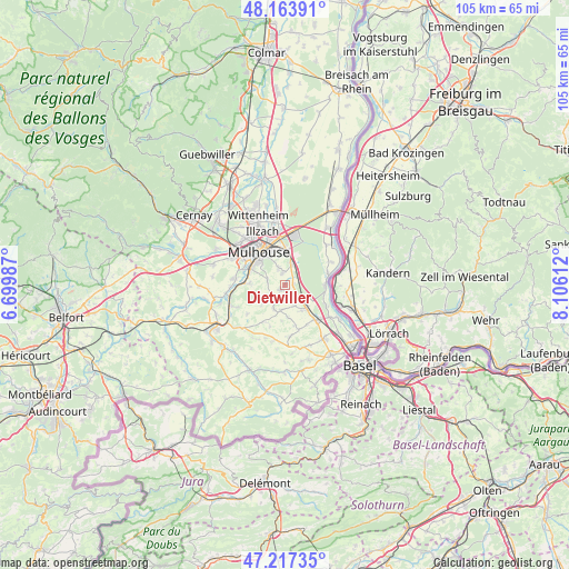
Dietwiller GPS coordinates[2]
47° 41' 34.008" North, 7° 24' 10.8" East
| Map corner | latitude | longitude |
|---|---|---|
| Upper-left | 48.16391°, | 6.69987° |
| Center: | 47.69278°, | 7.403° |
| Lower-right: | 47.21735°, | 8.10612° |
| Map W x H: | 105.2×105.2 km | = 65.4×65.4mi |
| max Lat: | 51.07786° ⇑45.9% North |
| Dietwiller: | 47.69278° |
| min Lat: | ⇓54.1% South 41.3874° |
| min Long | Dietwiller | max Long |
| -5.08615° | 7.403° | 9.52242° |
| W 97.3%⇐ | ⇒2.7% E |
Elevation
Elevation of Dietwiller is 250 m = 820 ft, and this is 56.3 m = 185 ft above average elevation for this country.
| Max E: |
2333 m = 7654 ft | 24.9% |
| Dietwiller | 250 m 820 ft | |
| Avg. | 193.7 m = 635 ft | |
Min E: |
-1 m = -3 ft | 75.1% |
See also: France elevation on elevation.city.
Geographical zone
Dietwiller is located in North temperate zone (between Tropic of Cancer and the Arctic Circle). Distance of this North polar circle is 2098.2 km =1303.8 mi to North.| Distance of | km | miles | from Dietwiller |
|---|---|---|---|
| North Pole | 4704.1 | 2923 | to North |
| Arctic Circle | 2098.2 | 1303.8 | to North |
| Tropic Cancer | 2697 | 1675.8 | to South |
| Equator | 5302.9 | 3295.1 | to South |


Nearby cities:
15 places around Dietwiller: (largest is in red/bold)
• Bruebach
3.4 km =2.1 mi,  284°
284°
• Eschentzwiller
2.2 km =1.4 mi,  349°
349°
• Flaxlanden
6.6 km =4.1 mi,  272°
272°
• Habsheim
4.3 km =2.7 mi,  15°
15°
• Kœtzingue
5 km =3.1 mi,  197°
197°
• Landser
1.3 km =0.8 mi,  228°
228°
• Rantzwiller
5 km =3.1 mi, 204°
• Rixheim
6.3 km =3.9 mi,  359°
359°
• Schlierbach
1.1 km =0.7 mi,  163°
163°
• Sierentz
5.4 km =3.4 mi,  135°
135°
• Steinbrunn-le-Bas
3.3 km =2.1 mi, 233°
• Steinbrunn-le-Haut
5.5 km =3.4 mi, 228°
• Uffheim
5.6 km =3.5 mi,  148°
148°
• Waltenheim
4.3 km =2.7 mi, 156°
• Zimmersheim
3.3 km =2.1 mi,  340°
340°
Sources, notices
• [Note1] Compared only with cities in France existing in our database
• [Src1] Map data: © OpenStreetMap contributors (CC-BY-SA)
• [Src2] Other city data from geonames.org with taken over terms of usage.
• [Src3] Geographical zone / Annual Mean Temperature by Robert A. Rohde @ Wikipedia
