Juilly geodata
Juilly (Île-de-France) is a populated place; located in France in Europe/Paris (GMT+2) time zone. With population of 2,195 people, there are 4376 cities with bigger population in this country. Compared to other cities in France, 80% of cities are located further ↓South; 53.6% of cities are located further ←West and 66% of cities have higher elevation than Juilly. Note1
Administrative division(s):
- Level 1: Île-de-France
- Level 2: Seine-et-Marne
- Level 3: Arrondissement de Meaux
- Level 4: Juilly


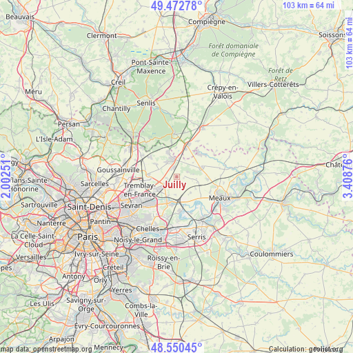
Juilly GPS coordinates[2]
49° 0' 49.5" North, 2° 42' 20.268" East
| Map corner | latitude | longitude |
|---|---|---|
| Upper-left | 49.47278°, | 2.00251° |
| Center: | 49.01375°, | 2.70563° |
| Lower-right: | 48.55045°, | 3.40876° |
| Map W x H: | 102.6×102.6 km | = 63.8×63.8mi |
| max Lat: | 51.07786° ⇑20% North |
| Juilly: | 49.01375° |
| min Lat: | ⇓80% South 41.3874° |
| min Long | Juilly | max Long |
| -5.08615° | 2.70563° | 9.52242° |
| W 53.6%⇐ | ⇒46.4% E |
Elevation
Elevation of Juilly is 87 m = 285 ft, and this is 106.7 m = 350 ft below average elevation for this country.
| Max E: |
2333 m = 7654 ft | 66% |
| Avg. | 193.7 m = 635 ft | |
| Juilly | 87 m = 285 ft | |
Min E: |
-1 m = -3 ft | 34% |
See also: France elevation on elevation.city.
Geographical zone
Juilly is located in North temperate zone (between Tropic of Cancer and the Arctic Circle). Distance of this North polar circle is 1951.4 km =1212.5 mi to North.| Distance of | km | miles | from Juilly |
|---|---|---|---|
| North Pole | 4557.2 | 2831.7 | to North |
| Arctic Circle | 1951.4 | 1212.5 | to North |
| Tropic Cancer | 2843.9 | 1767.1 | to South |
| Equator | 5449.8 | 3386.3 | to South |


Nearby cities:
15 places around Juilly: (largest is in red/bold)
• Charny
6.2 km =3.9 mi,  139°
139°
• Compans
3.7 km =2.3 mi,  234°
234°
• Dammartin-en-Goële
4.9 km =3 mi,  335°
335°
• Gressy
5.9 km =3.7 mi,  203°
203°
• Iverny
6.3 km =3.9 mi,  103°
103°
• Longperrier
4.8 km =3 mi,  322°
322°
• Messy
5.3 km =3.3 mi,  184°
184°
• Montgé-en-Goële
3.9 km =2.4 mi,  56°
56°
• Moussy-le-Vieux
7 km =4.3 mi,  302°
302°
• Rouvres
5.5 km =3.4 mi,  8°
8°
• Saint-Mard
2.7 km =1.7 mi,  345°
345°
• Saint-Mesmes
3.3 km =2.1 mi,  193°
193°
• Thieux
2.5 km =1.6 mi,  254°
254°
• Villeneuve-sous-Dammartin
5.3 km =3.3 mi, 296°
• Villeroy
6.5 km =4 mi,  121°
121°
Sources, notices
• [Note1] Compared only with cities in France existing in our database
• [Src1] Map data: © OpenStreetMap contributors (CC-BY-SA)
• [Src2] Other city data from geonames.org with taken over terms of usage.
• [Src3] Geographical zone / Annual Mean Temperature by Robert A. Rohde @ Wikipedia
